Page 423 - Geosystems An Introduction to Physical Geography 4th Canadian Edition
P. 423
 Crustal Formation
How did Earth’s continental crust form? What gave rise to the three orders of relief just discussed? Earth’s surface is a battleground of opposing processes: On the one hand, tec- tonic activity, driven by our planet’s internal energy, builds crust; on the other hand, the exogenic processes of weather- ing and erosion, powered by the Sun and occurring through the actions of air, water, waves, and ice, wear down crust.
Tectonic activity generally is slow, requiring mil- lions of years. Endogenic processes result in gradual uplift and new landforms, with major mountain build- ing occurring along plate boundaries. The uplifted crustal regions are quite varied but can be grouped into three general categories:
• Residual mountains and stable continental cratons, consisting of inactive remnants of ancient tectonic activity
• Tectonic mountains and landforms, produced by ac- tive folding, faulting, and crustal movements
• Volcanic landforms, formed by the surface accumu- lation of molten rock from eruptions of subsurface materials
The various processes mentioned in these descrip- tions operate in concert to produce the continental crust we see around us.
Continental Shields
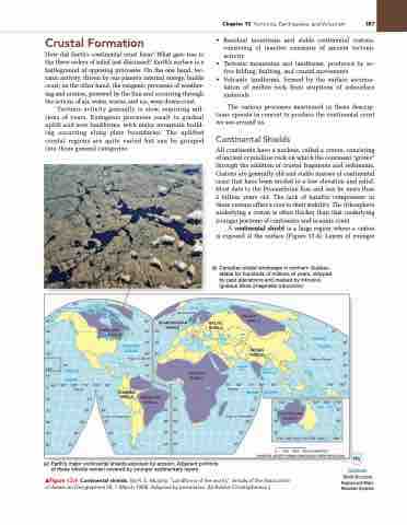
All continents have a nucleus, called a craton, consisting of ancient crystalline rock on which the continent “grows” through the addition of crustal fragments and sediments. Cratons are generally old and stable masses of continental crust that have been eroded to a low elevation and relief. Most date to the Precambrian Eon and can be more than 2 billion years old. The lack of basaltic components in these cratons offers a clue to their stability. The lithosphere underlying a craton is often thicker than that underlying younger portions of continents and oceanic crust.
A continental shield is a large region where a craton is exposed at the surface (Figure 13.4). Layers of younger
60° 50° 40° 30°
160° 10°
Arctic Circle 60° SCANDINAVIAN
BALTIC SHIELD
ANGARA SHIELD
70°
80°
ARCTIC OCEAN
20°
PACIFIC OCEAN
ARCTIC OCEAN
0°140° 130° 120° 110° 100° 90° Equator
50° 60° 70° 80° 90°
140° 150°
150° 160° 170° CORAL SEA 20°
30°
10° 20° 30° 40° 50°
10° 20°
30°
10°
50°
40°
40°
110° 120° 130° 140° 150° 160° 180°
0 1000 2000 3000 KILOMETRES
MODIFIED GOODE'S HOMOLOSINE EQUAL-AREA PROJECTION
CANADIAN SHIELD
50° 50° 40° 40° 30° 30°
SHIELD
0°
10° 20° 20° 30° 30° 40° 40° 50° 50°
50°
20°
Tropic of Capricorn
30° 40°
50°
20° Tropic of Capricorn 30°
40° 50°
30°
SHIELD
ATLANTIC OCEAN
INDIAN SHIELD
BAY OF BENGAL
PACIFIC OCEAN
Tropic of Cancer
40° 30° 20° 10°
GUIANAN SHIELD
Equator
INDIAN
10°
OCEAN
120° 20°
AUSTRALIAN
Tropic of Cancer 20°
ARABIAN SEA
(a) Earth’s major continental shields exposed by erosion. Adjacent portions of these shields remain covered by younger sedimentary layers.
Notebook
World Structural Regions and Major Mountain Systems
10°
BRAZILIAN SHIELD
AFRICAN SHIELD
▲Figure 13.4 Continental shields. [(a) R. E. Murphy, “Landforms of the world,” Annals of the Association of American Geographers 58, 1 (March 1968). Adapted by permission. (b) Bobbé Christopherson.]
Chapter 13 Tectonics, Earthquakes, and Volcanism 387
(b) Canadian shield landscape in northern Québec, stable for hundreds of millions of years, stripped by past glaciations and marked by intrusive igneous dikes (magmatic intrusions).


