Page 492 - Geosystems An Introduction to Physical Geography 4th Canadian Edition
P. 492
 456 part III The Earth–Atmosphere Interface
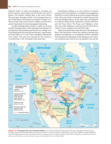
different bodies of water surrounding a continent; for North America, these bodies are the Pacific, the Gulf of Mexico, the Atlantic, Hudson Bay, or the Arctic Ocean. The principal drainage divides and drainage basins in the United States and Canada are mapped in Figure 15.3. These divides form water-resource regions and provide a spatial framework for water-management planning.
A major drainage basin system is made up of many smaller drainage basins. Each drainage basin gathers its precipitation and sediment and delivers it to a larger river, concentrating the flow into the main stream. A good exam- ple from Figure 15.3 is the Peace–Athabasca–Mackenzie river system. The total area drained by this system is 1.8 million km2, 18% of Canada’s total land mass.
Precipitation falling in an area collects in streams and may travel vast distances. Consider the precipitation that falls in central Alberta as far south as Jasper National Park. This water flows in hundreds of small streams that join the Athabasca River. At the same time, precipitation in northern Alberta feeds hundreds of streams that flow into the Peace River. The Peace and Athabasca rivers flow into Lake Athabasca, and then into the Slave River, which, in turn, empties into Great Slave Lake.
Water from Great Slave Lake flows into the Mackenzie River. The Liard River collects the outflow of streams that gathered precipitation in northeastern British Columbia and then joins the Mackenzie at Fort Simpson, and contin- ues northward past Inuvik into the Beaufort Sea and the
60°N
170°E
Bering Sea
ARCTIC OCEAN
Beaufort Sea
20°W
30°W
40°W
50°W
60°W
70°N
80°N
180°
170°W
160°W
150°W
Arctic drainage
YUKON
PACIFIC COASTAL
FRASER
COLUMBIA
GREAT BASIN Internal
Drainage
LOWER COLORADO
120°W 110°W
Arctic drainage
Baffin Bay
Hudson Bay
60°N
Pacific drainage
Arctic Circle
50°N
A
B
R
A
D
O
R
–
N
E
W
F
O
U
N
D
L
A
N
D
North Atlantic drainage
40°N
Pacific drainage
40°N
C
R
E
A
P
O
P
D
L
U
A
R
S
I
O
50°N
F
L
30°N
O
O
E
C
E
R
140°W
PACIFIC OCEAN
KEEWATIN
DRAINAGE BASIN DISCHARGE
SASKATCHEWAN
NELSON
ASSINIBOINE– RED
MARITIME COASTAL
CANADA:
millions m3 per year
Hudson Bay 682 000 Atlantic 670 000 Pacific 602 000 Arctic 440 000
Gulf of Mexico 105
UNITED STATES: millions m3 per year
Gulf/Atlantic 886 000 Pacific 412 000 Atlantic 361 000
Continental divides
GREAT LAKES
S
I
E
N
N
P
N
E
T
30°N
I
P
A
I
S
S
I
S
S
I
M
R
E
W
O
L
0 250
130°W
500 KILOMETRES
Gulf of Alaska
ARCTIC COAST AND ISLANDS MACKENZIE
Labrador Sea
PEACE– ATHABASCA
Hudson Bay drainage
NORTHERN QUEBEC
ST. LAWRENCE
CHURCHILL
NORTH SLOPE– GASPÉ
MISSOURI
UPPER MISSISSIPPI
NORTH ATLANTIC
Atlantic drainage
80°W
ARKANSAS–WHITE–RED
TEXAS–GULF GRANDE
RIO
20°N
20°N
T
r
o
p
i
c
o
f
C
a
n
L
c
e
r
▲Figure 15.3 Drainage basins and continental divides. Continental divides (red lines) separate the major drainage basins that empty through Canada and the United States into the Pacific, Atlantic, and Arctic Oceans, Hudson Bay, and the gulf of Mexico. Subdividing these major drainage basins are major river basins. [After U.S. geological Survey; The National Atlas of Canada, 1985, “Energy, Mines, and Resources Canada”; and Environment Canada, Currents of Change—Inquiry on Federal Water Policy—Final Report 1986.]
OHIO
SOUTH ATLANTIC– GULF
Gulf of Mexico
90°W
ATLANTIC OCEAN
Gulf/Atlantic drainage
70°E


