Page 493 - Geosystems An Introduction to Physical Geography 4th Canadian Edition
P. 493
 Arctic Ocean. Each tributary, large or small, adds its flow and sediment load to the larger river it joins. When water enters a body of standing water such as a lake or the sea, sediment accumulates. Sediment weathered and eroded in central Alberta and northeastern British Columbia is carried by rivers and is eventually deposited in the Peace- Athabasca, Slave, and Mackenzie river deltas.
CRITICALthinking 15.1 Locate Your Drainage Basin
Determine the name of the drainage basin within which your campus is located. Where are its headwaters? Where is the river’s mouth? Use Figure 15.3 to locate the larger drainage basins and divides for your region, and then take a look at this region on google EarthTM. Investigate whether any regulatory organization oversees planning and coordination for the drainage basin you identified. Can you find topographic maps online that cover this region? •
Drainage Basins as Open Systems
Drainage basins are open systems. Inputs include precipi- tation and the minerals and rocks of the regional geology. Energy and materials are redistributed as the stream con- stantly adjusts to its landscape. System outputs of water and sediment disperse through the mouth of the stream or river, into a lake, another stream or river, or the ocean, as shown in Figure 15.1.
Change that occurs in any portion of a drainage basin can affect the entire system. If a stream is brought to a geomorphic threshold where it can no longer maintain its present form, the river system may become destabilized, initiating a transition period to a more stable condition. A river system constantly struggles toward equilibrium among the interacting variables of discharge, chan- nel steepness, channel shape, and sediment load, all of which are discussed in the chapter ahead.
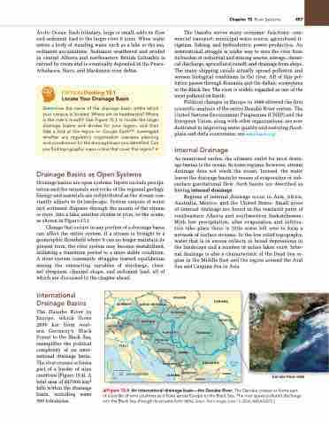
The Danube serves many economic functions: com- mercial transport, municipal water source, agricultural ir- rigation, fishing, and hydroelectric power production. An international struggle is under way to save the river from its burden of industrial and mining wastes, sewage, chemi- cal discharge, agricultural runoff, and drainage from ships. The many shipping canals actually spread pollution and worsen biological conditions in the river. All of this pol- lution passes through Romania and the deltaic ecosystems in the Black Sea. The river is widely regarded as one of the most polluted on Earth.
Political changes in Europe in 1989 allowed the first scientific analysis of the entire Danube River system. The United Nations Environment Programme (UNEP) and the European Union, along with other organizations, are now dedicated to improving water quality and restoring flood- plain and delta ecosystems; see www.icpdr.org/.
Internal Drainage
As mentioned earlier, the ultimate outlet for most drain- age basins is the ocean. In some regions, however, stream drainage does not reach the ocean. Instead, the water leaves the drainage basin by means of evaporation or sub- surface gravitational flow. Such basins are described as having internal drainage.
Regions of internal drainage occur in Asia, Africa, Australia, Mexico, and the United States. Small areas of internal drainage are found in the semiarid parts of southeastern Alberta and southwestern Saskatchewan. With low precipitation, after evaporation and infiltra- tion take place there is little water left over to form a network of surface streams. In the low relief topography, water that is in excess collects in broad depressions in the landscape and a number of saline lakes exist. Inter- nal drainage is also a characteristic of the Dead Sea re- gion in the Middle East and the region around the Aral Sea and Caspian Sea in Asia.
International
Drainage Basins
The Danube River in Europe, which flows 2850 km from west- ern Germany’s Black Forest to the Black Sea, exemplifies the political complexity of an inter- national drainage basin. The river crosses or forms part of a border of nine countries (Figure 15.4). A total area of 817000 km2 falls within the drainage basin, including some 300 tributaries.
GERMANY
POLAND
SLOVAKIA
UKRAINE
MOLDOVA
e
D
n
i
ni
e
b
e
h
u
s
n
t
R
e
a
r
D
D
a
n
SWITZERLAND
u
b
e
P
o
e
b
u
A
n
D
a
D
R
I
A
T
I
C
0 100 10°
200 KILOMETRES
ALBANIA
MACEDONIA GREECE
Danube River delta
LIECH.
ITALY
CZECH REPUBLIC
AUSTRIA
HUNGARY CROATIA
BOSNIA AND HERZEGOVINA
SLOVENIA
ROMANIA
BULGARIA
MONTENEGRO
KOSOVO
BLACK SEA
TURKEY
SERBIA
▲Figure 15.4 An international drainage basin—the Danube River. The Danube crosses or forms part of a border of nine countries as it flows across Europe to the Black Sea. The river spews polluted discharge into the Black Sea through its arcuate-form delta. [Inset: Terra image, June 15, 2002, nASA/gSFC.]
Chapter 15 River Systems 457
S
E
A


