Page 494 - Geosystems An Introduction to Physical Geography 4th Canadian Edition
P. 494
 458 part III The Earth–Atmosphere Interface
  Drainage Patterns
A primary feature of any drainage basin is its drainage density, determined by dividing the total length of all stream channels in the basin by the area of the basin. The number and length of channels in a given area reflect the landscape’s regional geology and topography.
The drainage pattern is the arrangement of chan- nels in an area. Patterns are quite distinctive and are determined by a combination of regional steepness and relief; variations in rock resistance, climate, and hydrology; and structural controls imposed by the un- derlying rocks. Consequently, the drainage pattern of any land area on Earth is a remarkable visual summary of every geologic and climatic characteristic of that region.
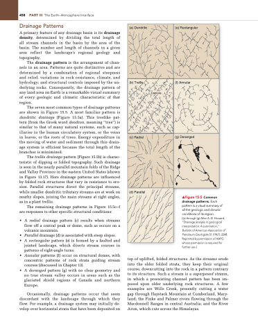
The seven most common types of drainage patterns are shown in Figure 15.5. A most familiar pattern is dendritic drainage (Figure 15.5a). This treelike pat- tern (from the Greek word dendron, meaning “tree”) is similar to that of many natural systems, such as cap- illaries in the human circulatory system, or the veins in leaves, or the roots of trees. Energy expenditure in the moving of water and sediment through this drain- age system is efficient because the total length of the branches is minimized.
The trellis drainage pattern (Figure 15.5b) is charac- teristic of dipping or folded topography. Such drainage is seen in the nearly parallel mountain folds of the Ridge and Valley Province in the eastern United States (shown in Figure 13.17). Here drainage patterns are influenced by folded rock structures that vary in resistance to ero- sion. Parallel structures direct the principal streams, while smaller dendritic tributary streams are at work on nearby slopes, joining the main streams at right angles, as in a plant trellis.
The remaining drainage patterns in Figure 15.5c–f are responses to other specific structural conditions:
• A radial drainage pattern (c) results when streams flow off a central peak or dome, such as occurs on a volcanic mountain.
• Parallel drainage (d) is associated with steep slopes.
• A rectangular pattern (e) is formed by a faulted and jointed landscape, which directs stream courses in
patterns of right-angle turns.
• Annular patterns (f) occur on structural domes, with
concentric patterns of rock strata guiding stream
courses (discussed in Chapter 13).
• A deranged pattern (g) with no clear geometry and
no true stream valley occurs in areas such as the glaciated shield regions of Canada and northern Europe.
Occasionally, drainage patterns occur that seem discordant with the landscape through which they flow. For example, a drainage system may initially de- velop over horizontal strata that have been deposited on
▲Figure 15.5 Common drainage patterns. Each pattern is a visual summary of all the geologic and climatic conditions of its region.
[(a) through (g) After A. D. Howard, “Drainage analysis in geological interpretation: A summation,” Bulletin of American Association of Petroleum Geologists 51 (1967): 2248. Reprinted by permission of AAPg whose permission is required for further use.]
top of uplifted, folded structures. As the streams erode into the older folded strata, they keep their original course, downcutting into the rock in a pattern contrary to its structure. Such a stream is a superposed stream, in which a preexisting channel pattern has been im- posed upon older underlying rock structures. A few examples are Wills Creek, presently cutting a water gap through Haystack Mountain at Cumberland, Mary- land; the Finke and Palmer rivers flowing through the Macdonnell Ranges in central Australia; and the River Arun, which cuts across the Himalayas.
  (a) Dendritic
(e) Rectangular
      (b) Trellis
Capture
(f) Annular
        (c) Radial
(g) Deranged
        (d) Parallel


