Page 508 - Geosystems An Introduction to Physical Geography 4th Canadian Edition
P. 508
 472 part III The Earth–Atmosphere Interface
  The tendency of natural systems, including streams, to move toward a state of equilibrium causes stream channels, over a period of years, to adjust their channel characteristics so that the flow is able to move the sedi- ment supplied from the drainage basin. A graded stream is one in which the channel slope has adjusted, given the discharge and channel conditions, so that stream veloc- ity is just enough to transport the sediment load.
A graded stream has the characteristic longitudi- nal profile illustrated in Figure 15.19. Any variation, or bump, in the profile, such as the steep drop of a water- fall, will be smoothed out over time as the stream ad- justs toward a graded condition. Attainment of a graded condition does not mean that the stream is at its lowest gradient, but rather that it has achieved a state of dy- namic equilibrium between its gradient and its sediment load. This balance depends on many factors that work together on the landscape and within the river system.
An individual stream can have both graded and un- graded portions, and it can have graded sections without having an overall graded slope. In fact, variations and interruptions are the rule rather than the exception. Disturbances in a drainage basin, such as mass wast- ing on hillslopes that carries material into stream chan- nels, or overgrazing of riparian vegetation and associated streambank instability, can cause disruptions to this equilibrium condition. The concept of stream gradation is intimately tied to stream gradient; any change in the characteristic longitudinal profile of a river causes the system to respond, seeking a graded condition. The fol- lowing discussions of tectonic uplift and of nickpoints delve further into this concept.
Tectonic Uplift A graded stream can be affected by tectonic uplift that changes the elevation of the stream relative to its base level. Such lifting of the landscape would increase the stream gradient, stimulating ero- sional activity. A previously low-energy river flowing through the uplifted landscape becomes rejuvenated; that is, the river gains energy and actively returns to downcutting. Degradation of the channel can eventually form entrenched meanders that are deeply incised in the landscape (Figure 15.20). Such a stream is called an ante- cedent stream (from the Greek ante, meaning before) be- cause it downcuts at the same rate the uplift occurs, thus maintaining its course. The South Nahanni River in the Northwest Territories is another example of an antecedent stream. Note that superposed streams, mentioned earlier, do not downcut as uplift occurs; instead, they superpose their original course on older rock strata that become ex- posed by erosion.
nickpoints When the longitudinal profile of a stream contains an abrupt change in gradient, such as at a wa- terfall or an area of rapids, the point of interruption is a nickpoint (also spelled knickpoint). Nickpoints can re- sult when a stream flows across a resistant rock layer or a recent fault line or area of surface deformation. Tem- porary blockage in a channel, caused by a landslide or a
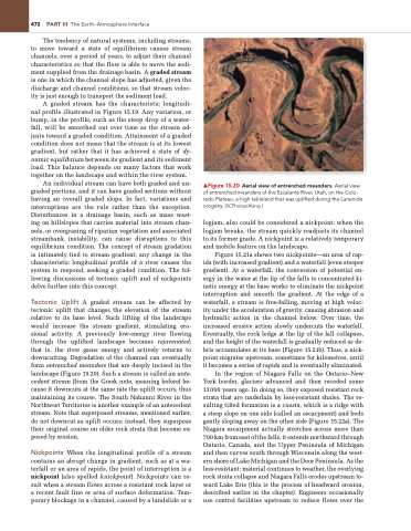
▲Figure 15.20 Aerial view of entrenched meanders. Aerial view of entrenched meanders of the Escalante River, Utah, on the Colo- rado Plateau, a high tableland that was uplifted during the Laramide orogeny. [SCPhotos/Alamy.]
logjam, also could be considered a nickpoint; when the logjam breaks, the stream quickly readjusts its channel to its former grade. A nickpoint is a relatively temporary and mobile feature on the landscape.
Figure 15.21a shows two nickpoints—an area of rap- ids (with increased gradient) and a waterfall (even steeper gradient). At a waterfall, the conversion of potential en- ergy in the water at the lip of the falls to concentrated ki- netic energy at the base works to eliminate the nickpoint interruption and smooth the gradient. At the edge of a waterfall, a stream is free-falling, moving at high veloc- ity under the acceleration of gravity, causing abrasion and hydraulic action in the channel below. Over time, the increased erosive action slowly undercuts the waterfall. Eventually, the rock ledge at the lip of the fall collapses, and the height of the waterfall is gradually reduced as de- bris accumulates at its base (Figure 15.21b). Thus, a nick- point migrates upstream, sometimes for kilometres, until it becomes a series of rapids and is eventually eliminated.
In the region of Niagara Falls on the Ontario–New York border, glaciers advanced and then receded some 13000 years ago. In doing so, they exposed resistant rock strata that are underlain by less-resistant shales. The re- sulting tilted formation is a cuesta, which is a ridge with a steep slope on one side (called an escarpment) and beds gently sloping away on the other side (Figure 15.22a). The Niagara escarpment actually stretches across more than 700 km from east of the falls, it extends northward through Ontario, Canada, and the Upper Peninsula of Michigan and then curves south through Wisconsin along the west- ern shore of Lake Michigan and the Door Peninsula. As the less-resistant: material continues to weather, the overlying rock strata collapse and Niagara Falls erodes upstream to- ward Lake Erie (this is the process of headward erosion, described earlier in the chapter). Engineers occasionally use control facilities upstream to reduce flows over the


