Page 509 - Geosystems An Introduction to Physical Geography 4th Canadian Edition
P. 509
Chapter 15 River Systems 473
   Rapids
Waterfall
Weaker strata (shale)
More resistant strata Nickpoint
Weaker strata (shale)
Nickpoint slowly
sediment. The process of fluvial depo- sition occurs when a stream deposits alluvium, thereby creating deposi- tional landforms, such as bars, flood- plains, terraces, and deltas.
Floodplains The flat, low-lying area adjacent to a channel and subjected to recurrent flooding is a flood- plain. It is the area that is inundated when the river overflows its channel during times of high flow. When the water recedes, it leaves behind allu-
Nickpoint
migrates upstream Erosion undercuts
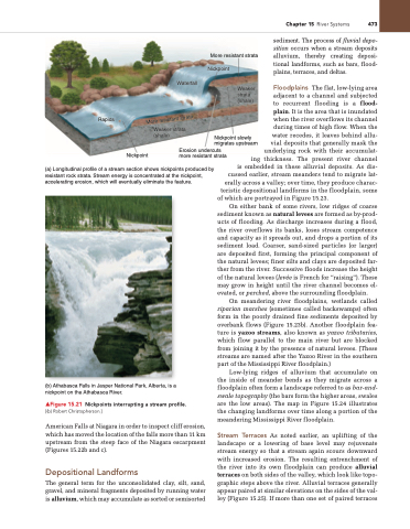
(a) Longitudinal profile of a stream section shows nickpoints produced by resistant rock strata. Stream energy is concentrated at the nickpoint, accelerating erosion, which will eventually eliminate the feature.
(b) Athabasca Falls in Jasper National Park, Alberta, is a nickpoint on the Athabasca River.
▲Figure 15.21 Nickpoints interrupting a stream profile. [(b) Robert Christopherson.]
American Falls at Niagara in order to inspect cliff erosion, which has moved the location of the falls more than 11 km upstream from the steep face of the Niagara escarpment (Figures 15.22b and c).
Depositional Landforms
The general term for the unconsolidated clay, silt, sand, gravel, and mineral fragments deposited by running water is alluvium, which may accumulate as sorted or semisorted
more resistant strata
vial deposits that generally mask the underlying rock with their accumulat- ing thickness. The present river channel is embedded in these alluvial deposits. As dis- cussed earlier, stream meanders tend to migrate lat- erally across a valley; over time, they produce charac- teristic depositional landforms in the floodplain, some
of which are portrayed in Figure 15.23.
On either bank of some rivers, low ridges of coarse
sediment known as natural levees are formed as by-prod- ucts of flooding. As discharge increases during a flood, the river overflows its banks, loses stream competence and capacity as it spreads out, and drops a portion of its sediment load. Coarser, sand-sized particles (or larger) are deposited first, forming the principal component of the natural levees; finer silts and clays are deposited far- ther from the river. Successive floods increase the height of the natural levees (levée is French for “raising”). These may grow in height until the river channel becomes el- evated, or perched, above the surrounding floodplain.
On meandering river floodplains, wetlands called riparian marshes (sometimes called backswamps) often form in the poorly drained fine sediments deposited by overbank flows (Figure 15.23b). Another floodplain fea- ture is yazoo streams, also known as yazoo tributaries, which flow parallel to the main river but are blocked from joining it by the presence of natural levees. (These streams are named after the Yazoo River in the southern part of the Mississippi River floodplain.)
Low-lying ridges of alluvium that accumulate on the inside of meander bends as they migrate across a floodplain often form a landscape referred to as bar-and- swale topography (the bars form the higher areas, swales are the low areas). The map in Figure 15.24 illustrates the changing landforms over time along a portion of the meandering Mississippi River floodplain.
Stream Terraces As noted earlier, an uplifting of the landscape or a lowering of base level may rejuvenate stream energy so that a stream again scours downward with increased erosion. The resulting entrenchment of the river into its own floodplain can produce alluvial terraces on both sides of the valley, which look like topo- graphic steps above the river. Alluvial terraces generally appear paired at similar elevations on the sides of the val- ley (Figure 15.25). If more than one set of paired terraces
 More resistant strata


