Page 510 - Geosystems An Introduction to Physical Geography 4th Canadian Edition
P. 510
 474 part III The Earth–Atmosphere Interface
  Headward erosion of the falls
    Niagara escarpment
Notebook
Niagara Falls
N
Niagara gorge
Lake Ontario
Niagara Falls
10 km
Lake Erie
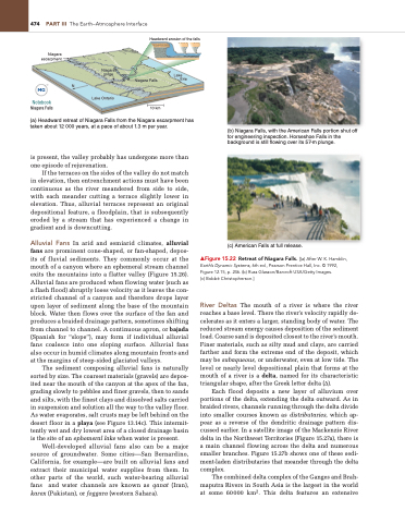
(a) Headward retreat of Niagara Falls from the Niagara escarpment has taken about 12 000 years, at a pace of about 1.3 m per year.
is present, the valley probably has undergone more than one episode of rejuvenation.
If the terraces on the sides of the valley do not match in elevation, then entrenchment actions must have been continuous as the river meandered from side to side, with each meander cutting a terrace slightly lower in elevation. Thus, alluvial terraces represent an original depositional feature, a floodplain, that is subsequently eroded by a stream that has experienced a change in gradient and is downcutting.
Alluvial Fans In arid and semiarid climates, alluvial fans are prominent cone-shaped, or fan-shaped, depos- its of fluvial sediments. They commonly occur at the mouth of a canyon where an ephemeral stream channel exits the mountains into a flatter valley (Figure 15.26). Alluvial fans are produced when flowing water (such as a flash flood) abruptly loses velocity as it leaves the con- stricted channel of a canyon and therefore drops layer upon layer of sediment along the base of the mountain block. Water then flows over the surface of the fan and produces a braided drainage pattern, sometimes shifting from channel to channel. A continuous apron, or bajada (Spanish for “slope”), may form if individual alluvial fans coalesce into one sloping surface. Alluvial fans also occur in humid climates along mountain fronts and at the margins of steep-sided glaciated valleys.
The sediment composing alluvial fans is naturally sorted by size. The coarsest materials (gravels) are depos- ited near the mouth of the canyon at the apex of the fan, grading slowly to pebbles and finer gravels, then to sands and silts, with the finest clays and dissolved salts carried in suspension and solution all the way to the valley floor. As water evaporates, salt crusts may be left behind on the desert floor in a playa (see Figure 13.14c). This intermit- tently wet and dry lowest area of a closed drainage basin is the site of an ephemeral lake when water is present.
Well-developed alluvial fans also can be a major source of groundwater. Some cities—San Bernardino, California, for example—are built on alluvial fans and extract their municipal water supplies from them. In other parts of the world, such water-bearing alluvial fans and water channels are known as qanat (Iran), karex (Pakistan), or foggara (western Sahara).
(b) Niagara Falls, with the American Falls portion shut off for engineering inspection. Horseshoe Falls in the background is still flowing over its 57-m plunge.
  (c) American Falls at full release.
▲Figure 15.22 Retreat of Niagara Falls. [(a) After W. K. Hamblin, Earth’s Dynamic Systems, 6th ed., Pearson Prentice Hall, Inc. © 1992, Figure 12.15, p. 246. (b) Russ glasson/Barcroft USA/getty Images.
(c) Bobbé Christopherson.]
River Deltas The mouth of a river is where the river reaches a base level. There the river’s velocity rapidly de- celerates as it enters a larger, standing body of water. The reduced stream energy causes deposition of the sediment load. Coarse sand is deposited closest to the river’s mouth. Finer materials, such as silty mud and clays, are carried farther and form the extreme end of the deposit, which may be subaqueous, or underwater, even at low tide. The level or nearly level depositional plain that forms at the mouth of a river is a delta, named for its characteristic triangular shape, after the Greek letter delta (Δ).
Each flood deposits a new layer of alluvium over portions of the delta, extending the delta outward. As in braided rivers, channels running through the delta divide into smaller courses known as distributaries, which ap- pear as a reverse of the dendritic drainage pattern dis- cussed earlier. In a satellite image of the Mackenzie River delta in the Northwest Territories (Figure 15.27a), there is a main channel flowing across the delta and numerous smaller branches. Figure 15.27b shows one of these sedi- ment-laden distributaries that meander through the delta complex.
The combined delta complex of the Ganges and Brah- maputra Rivers in South Asia is the largest in the world at some 60000 km2. This delta features an extensive


