Page 512 - Geosystems An Introduction to Physical Geography 4th Canadian Edition
P. 512
 476 part III The Earth–Atmosphere Interface
 Animation
Stream Terrace Formation
Alluvial terraces (paired)
sediment or that discharge into strong erosive currents. The Columbia River of the U.S. Northwest lacks a delta because offshore currents remove sediment as quickly as it is deposited.
An interesting case of delta formation, the Horton River delta in the Northwest Territories, is shown in the Visual Analysis at the end of this chapter.
Fraser River Delta The Fraser River delta was formed as sediment accumulated where the Fraser River now flows into the Strait of Georgia (Figure 15.30). Deglacia- tion of the region and the rapid development of the Fra- ser River floodplain westward down a glacially scoured, partially submerged trough preceded initial delta growth. As the floodplain extended westward, fluvial, deltaic, marine, and lacustrine sediments covered the floor of the trough.
About 10000 years ago, the Fraser River began to empty directly into the Strait of Georgia through a gap in the Pleistocene uplands at New Westminster. Deposition has advanced the delta front seaward 25 km over the past 10 000 years, creating a landform that covers about 1000 km2. Floods deposited silt and clay on the Fraser delta plain until the 1900s, when dikes were constructed for protection of human development. The dikes sta- bilized the river channel, slowing natural processes. Dredging maintains shipping channels downstream from New Westminster and dredged sand is not depos- ited on the delta front. The impact of human activity was to decrease the rate of sediment delivery to the edge of the delta. Erosion dominates in some areas, increasing the delta slope and the risk of delta-slope failure. Prehis- toric and historic failures are in evidence across the sub- marine slope of the Fraser delta.
The delta is an important agricultural area with deep, fertile sediment and a favourable climate. In- fringing on this land use are urban development and industrial growth. The area is also valuable as habitat for migratory waterfowl and salmon fry. Also, the delta is threatened by earthquake hazard. Liquefaction, the fluidization of water-saturated sediment when shaken, will cause subsidence of the delta plain and may cause buildings that are not properly anchored to tilt or col- lapse. Small earthquakes are common in the area, but a large-scale quake has not happened in the last hundred years. However, geological evidence indicates it is in- evitable that the “big one” will occur (see more about this in Focus Study 13.1.).
Mississippi River Delta Over the past 120 million years, the Mississippi River has transported alluvium throughout its vast basin into the Gulf of Mexico. Dur- ing the past 5000 years, the river has formed a succession of seven distinct deltaic complexes along the Louisiana coast. Each new complex formed after the river changed course, probably during an episode of catastrophic flood- ing. The first of these deltas was located near the mouth of the Atchafalaya River. The seventh and current delta
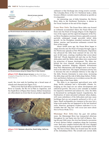
 (a) Alluvial terraces are formed as a stream cuts into a valley.
  (b) Alluvial terraces along the Rakaia River in New Zealand.
▲Figure 15.25 Alluvial stream terraces. [(a) After W. M. Davis, Geographical Essays (new york: Dover, 1964 [1909]), p. 515. (b) Bill Bachman/ Science Source.]
result, the river ends by braiding into a broad maze of islands and channels (see Figure 15.1).
Other rivers that lack deltas include the St. Lawrence River in Canada, the Rio de la Plata in Argentina, and the Sepik River of Papua New Guinea. Deltaic formations are often absent on rivers that do not produce significant
▲Figure 15.26 Badwater alluvial fan, Death Valley, California. [USgS.]


