Page 514 - Geosystems An Introduction to Physical Geography 4th Canadian Edition
P. 514
 478 part III The Earth–Atmosphere Interface
      0
INDIA
25 50
100 KILOMETRES
Bay of Bengal
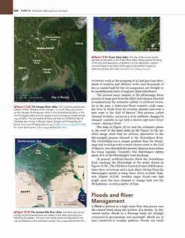
▲Figure 15.28 The Ganges River delta. The complex distributary pattern of the “Mouths of the ganges” in South Asia, also known
as the ganges–Brahmaputra delta or the Sundarbands delta, is the world’s largest delta and the largest tract of mangrove forest remain- ing on Earth. The Sundarbands national Park is a UnESCO World Heritage site, home to Bengal tigers, ganges and Irrawaddy dol- phins, and a rare finless porpoise; go to whc.unesco.org/en/list/452 for more information. [Terra images/nASA/gSFC/JPL.]
▲Figure 15.29 The arcuate Nile River delta. Intensive agricultural activity and small settlements are visible on the delta and along the nile River floodplain. The two main distributaries are Damietta to the east and Rosetta to the west (see arrows). [Terra image, nASA/gSFC/JPL.]
▲Figure 15.30 Fraser River delta. The city of Vancouver and its suburbs are situated on the Fraser River delta. Dikes prevent flooding of the river and deposition of sediment on the delta plain. Lighter- coloured areas in the Strait of georgia in this satellite image are sediment plumes. [WorldSat International Inc./Science Source.]
Activities such as the pumping of oil and gas from thou- sands of onshore and offshore wells, and thousands of km in canals built by the oil companies, are thought to be an additional cause of regional land subsidence.
The present main channel of the Mississippi River persists in large part from the effort and expense directed at maintaining the extensive system of artificial levees. As in the past, a worst-case flood scenario could cause the river to break from its existing channel and seek a new route to the Gulf of Mexico. This process, called channel avulsion, occurs as a river suddenly changes its channel—usually to one with a shorter and more direct course—during a flood.
The map in Figure 15.31c and the sediment plume to the west of the main delta in the Figure 15.31b sat- ellite image show that an obvious alternative to the Mississippi’s present channel is the Atchafalaya River. The Atchafalaya has a steeper gradient than the Missis- sippi and would provide a much shorter route to the Gulf of Mexico, less than half the present distance from where the rivers separate. Currently, this distributary carries about 30% of the Mississippi’s total discharge.
At present, artificial barriers block the Atchafalaya from reaching the Mississippi at the point shown in Figure 15.31c. The Old River Control Project (1963) main- tains three structures and a lock about 320 km from the Mississippi’s mouth to keep these rivers in their chan- nels (Figure 15.31d). Another major f lood—one that might cause the river channel to change back into the Atchafalaya—is only a matter of time.
Floods and River Management
A flood is defined as a high water flow that passes over the natural bank along any portion of a stream. As dis- cussed earlier, floods in a drainage basin are strongly connected to precipitation and snowmelt, which are in turn connected to weather patterns. Floods can result
Mediterranean Sea
Nile Delta
EGYPT
Cairo
Sinai
Gulf of Suez
Brahmaputra River
BANGLADESH
Ganges River
Ganges Delta
INDIA
0 10 20 KILOMETRES
  Nile River
0 25
50 KILOMETRES


