Page 515 - Geosystems An Introduction to Physical Geography 4th Canadian Edition
P. 515
 Baton Rouge
A
t
c
h
a
f
a
l
y
a
e
a
New Orleans 2
4
7
Chapter 15 River Systems 479
R
i
v
r
River
Mississippi
A
t
c
R
h
a
i
v
f
e
a
r
l
a
y
a
94°
Gulf of Mexico
93° 92°
29° 91° 90° 89°
136 5
Gulf of Mexico
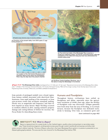
[Shaded areas denote areas of previous deltas.]
(a) Evolution of the present delta, from 5000 years (1) ago to the present (7).
Louisiana
Alexandria
0
Morgan City
(b) The bird’s-foot delta of the Mississippi River receives a continuous sediment supply, focused by controlling levees, although subsidence of the delta and rising sea level have diminished the overall surface area.
(c) Location of the Old Control Structures and potential capture point where the Atchafalaya River may one day divert the present channel.
from periods of prolonged rainfall over a broad region, from intense rainfall associated with short-lived thun- derstorms, from rapid melting of the snowpack, or from rain-on-snow events that accelerate snowpack melting. Floods vary in magnitude and frequency, and their ef- fects depend on many factors. Major flooding occurred in southern Alberta in 2013, causing extensive property damage and costing billions of dollars for recovery. See Focus Study 15.2 describing these events.
Georeport 15.2 What Is a Bayou?
humans and Floodplains
Throughout history, civilizations have settled on floodplains and deltas, especially since the agricul- tural revolution of 10000 years ago, when the fertility of floodplain soils was discovered. Villages generally were built away from the area of flooding, or on stream terraces, because the floodplain was dedicated exclu- sively to farming. Over time, as commerce grew and
(text continued on page 482)
40 80 KILOMETRES
Old River Control Project
Lake Pontchartrain
30° Orleans
New
(d) Old River Control Auxilliary Structure, one of the dams to keep the Mississippi in its channel.
▲Figure 15.31 The Mississippi River delta. [(a) Adapted from C. R. Kolb and J. R. Van Lopik, “Depositional environments of the Mississippi River deltaic plain,” in Deltas in Their Geologic Framework (Houston, TX: Houston geological Society, 1966). (b) Terra image courtesy of Liam gumley, Space Science and Engineering Center, University of Wisconsin, and nASA. (d) Bobbé Christopherson.]
Bayou is a general term for a water body in a flat, lowland region, usually a slow-moving stream or secondary water- way. These sometimes stagnant, winding watercourses pass through coastal marshlands and swamps and allow tidal
waters access to deltaic lowlands. The story of Bayou Lafourche in the lower Mississippi River system in Louisiana is presented on our MasteringGeography website. This area was the main channel for the Mississippi River before 1904.


