Page 626 - Geosystems An Introduction to Physical Geography 4th Canadian Edition
P. 626
 590 part IV Soils, Ecosystems, and Biomes
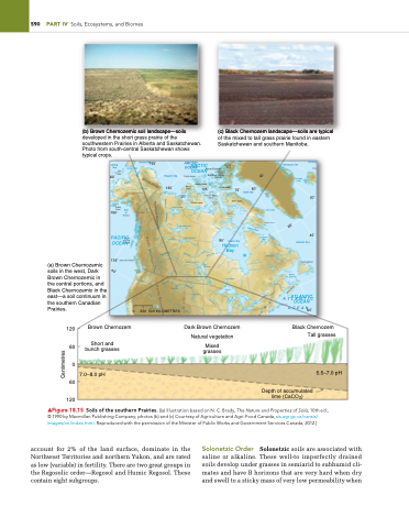
(a) Brown Chernozemic soils in the west, Dark Brown Chernozemic in the central portions, and Black Chernozemic in the east—a soil continuum in the southern Canadian Prairies.
135˚ Vancouver Island
Newfoundland
(b) Brown Chernozemic soil landscape—soils developed in the short grass prairie of the southwestern Prairies in Alberta and Saskatchewan. Photo from south-central Saskatchewan shows typical crops.
(c) Black Chernozem landscape—soils are typical of the mixed to tall grass prairie found in eastern Saskatchewan and southern Manitoba.
Norwegi
Faro
30˚
45˚
Brown Chernozem
Short and bunch grasses
7.0–8.0 pH 60
120
Dark Brown Chernozem Natural vegetation
Mixed grasses
Black Chernozem Tall grasses
5.5–7.0 pH
120 60 0
Bering Sea
Saint Lawrence Island
60˚
150˚ of Alaska
165˚
ARCTIC
Ellesmere Island
Greenland Sea
Denmark Strait
Kodiak
Island Gulf
Great Bear Lake
PACIFIC
Great Slave Lake
Lake Athabasca
Saskatchewan River
Lake Oahe
OCEAN
Hudson Bay
Lake Nipigon
L. Superior
Labrador Sea
Q
Bering Strait
OCEAN Queen Elizabeth
ueen
Peace River
Lake Sakakawea
90˚
Charlotte Islands
Mt Mckinley
75˚ Baffin Island
0
250 500 KILOMETRES
60˚
Olympic Mts.
Gulf of
St. Lawrence
Chukchi Sea
ARCTIC
Mt Logan
Melville Pen.
Hudson Bay
Davis Strait
Cape Howe
UnBgaayva
Smallwood Res.
Great Salt Lake
OCEAN
Beaufort Sea
135˚
Sverdrup Islands Islands
120˚
Prince of Wales Island
OCEAN
Patrick Island
Axel Heiberg Island
Melville Island Island 105˚
Banks
Devon Island
60˚
Baffin Bay
▲Figure 18.15 Soils of the southern Prairies. [(a) illustration based on N. C. Brady, The Nature and Properties of Soils, 10th ed., © 1990 by Macmillan Publishing Company; photos (b) and (c) Courtesy of Agriculture and Agri-Food Canada, sis.agr.gc.ca/cansis/ images/on/index.html. Reproduced with the permission of the Minister of Public Works and Government Services Canada, 2012.]
account for 2% of the land surface, dominate in the Northwest Territories and northern Yukon, and are rated as low (variable) in fertility. There are two great groups in the Regosolic order—Regosol and Humic Regosol. These contain eight subgroups.
Solonetzic Order Solonetzic soils are associated with saline or alkaline. These well-to imperfectly drained soils develop under grasses in semiarid to subhumid cli- mates and have B horizons that are very hard when dry and swell to a sticky mass of very low permeability when
Victoria Island
Boothia Pen.
Lake Winnipeg
L. Huron
ATLANTIC
ATLANTIC
Cape Cod
OCEAN
Depth of accumulated lime (CaCO3)
5
4
Brooks Range
Yukon R.
Yukon R.
Mackenzie R.
Mackenzie Mountains
Yukon R.
Mackenzie R.
60˚
Hudson Strait
Rocky Mountains Rocky Mountains
Churchill R
Athabasca River
Nelson River
45˚
Columbia R.
Columbia R.
Missouri R.
Missouri R.
Nova Scotia
Snake R.
Grea
St Lawrence R.
Mississippi R.
L. Michigan
L. Ontario
Platte River
L. Erie
an Mts.
Centimetres


