
Page 329 - NGTU_paper_withoutVideo
P. 329
Modern Geomatics Technologies and Applications
120
100
Vegetation
80
Road
60 Residental
Bare
40
Shadow
20
0
LISS- LISS- IRS-PAN IRS- IKONOS IKO
PB OB -PB PAN - -PB NOS-
OB OB
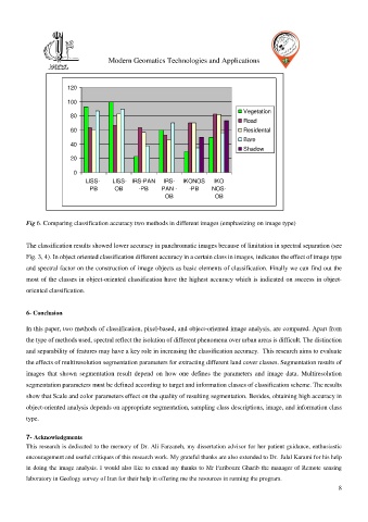
Fig 6. Comparing classification accuracy two methods in different images (emphasizing on image type)
The classification results showed lower accuracy in panchromatic images because of limitation in spectral separation (see
Fig. 3, 4). In object oriented classification different accuracy in a certain class in images, indicates the effect of image type
and spectral factor on the construction of image objects as basic elements of classification. Finally we can find out the
most of the classes in object-oriented classification have the highest accuracy which is indicated on success in object-
oriented classification.
6- Conclusion
In this paper, two methods of classification, pixel-based, and object-oriented image analysis, are compared. Apart from
the type of methods used, spectral reflect the isolation of different phenomena over urban areas is difficult. The distinction
and separability of features may have a key role in increasing the classification accuracy. This research aims to evaluate
the effects of multiresolution segmentation parameters for extracting different land cover classes. Segmentation results of
images that shown segmentation result depend on how one defines the parameters and image data. Multiresolution
segmentation parameters must be defined according to target and information classes of classification scheme. The results
show that Scale and color parameters effect on the quality of resulting segmentation. Besides, obtaining high accuracy in
object-oriented analysis depends on appropriate segmentation, sampling class descriptions, image, and information class
type.
7- Acknowledgments
This research is dedicated to the memory of Dr. Ali Farzaneh, my dissertation advisor for her patient guidance, enthusiastic
encouragement and useful critiques of this research work. My grateful thanks are also extended to Dr. Jalal Karami for his help
in doing the image analysis. I would also like to extend my thanks to Mr Faribourz Gharib the manager of Remote sensing
laboratory in Geology survey of Iran for their help in offering me the resources in running the program.
8