
Page 413 - NGTU_paper_withoutVideo
P. 413
Modern Geomatics Technologies and Applications
Evaluation methods are based on the comparison of identified samples with reference samples. There are several ways to
evaluate the identified lines. One of the essential evaluation methods is the confusion matrix (Table 2). This matrix has different
parameters; one of the most important parameters is overall accuracy. This factor calculates accuracy based on the number of
lines that were correctly identified. In other words, the ratio of the number of lines that were correctly classified for each class
to the total number of reference lines (Equation 6).
∑
= =1 (6)
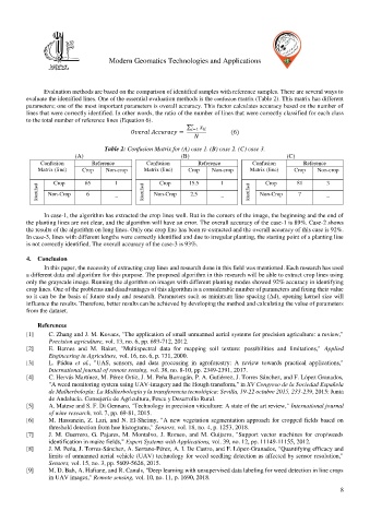
Table 2: Confusion Matrix for (A) case 1. (B) case 2. (C) case 3.
(A) (B) (C)
Confusion Reference Confusion Reference Confusion Reference
Matrix (line) Crop Non-crop Matrix (line) Crop Non-crop Matrix (line) Crop Non-crop
Crop
Crop
Crop
Identified Non-Crop 65 1 Identified Non-Crop 15.5 1 Identified Non-Crop 81 3
6
2.5
_
7
_
_
In case-1, the algorithm has extracted the crop lines well. But in the corners of the image, the beginning and the end of
the planting lines are not clear, and the algorithm will have an error. The overall accuracy of the case-1 is 89%. Case-2 shows
the results of the algorithm on long lines. Only one crop line has been re-extracted and the overall accuracy of this case is 92%.
In case-3, lines with different lengths were correctly identified and due to irregular planting, the starting point of a planting line
is not correctly identified. The overall accuracy of the case-3 is 93%.
4. Conclusion
In this paper, the necessity of extracting crop lines and research done in this field was mentioned. Each research has used
a different data and algorithm for this purpose. The proposed algorithm in this research will be able to extract crop lines using
only the grayscale image. Running the algorithm on images with different planting modes showed 92% accuracy in identifying
crop lines. One of the problems and disadvantages of this algorithm is a considerable number of parameters and fixing their value
so it can be the basis of future study and research. Parameters such as minimum line spacing (∆d), opening kernel size will
influence the results. Therefore, better results can be achieved by developing the method and calculating the value of parameters
from the dataset.
References
[1] C. Zhang and J. M. Kovacs, "The application of small unmanned aerial systems for precision agriculture: a review,"
Precision agriculture, vol. 13, no. 6, pp. 693-712, 2012.
[2] E. Barnes and M. Baker, "Multispectral data for mapping soil texture: possibilities and limitations," Applied
Engineering in Agriculture, vol. 16, no. 6, p. 731, 2000.
[3] L. Pádua et al., "UAS, sensors, and data processing in agroforestry: A review towards practical applications,"
International journal of remote sensing, vol. 38, no. 8-10, pp. 2349-2391, 2017.
[4] C. Hervás Martínez, M. Pérez Ortiz, J. M. Peña Barragán, P. A. Gutiérrez, J. Torres Sánchez, and F. López Granados,
"A weed monitoring system using UAV-imagery and the Hough transform," in XV Congreso de la Sociedad Española
de Malherbología: La Malherbología y la transferencia tecnológica: Sevilla, 19-22 octubre 2015, 233-239, 2015: Junta
de Andalucía. Consejería de Agricultura, Pesca y Desarrollo Rural.
[5] A. Matese and S. F. Di Gennaro, "Technology in precision viticulture: A state of the art review," International journal
of wine research, vol. 7, pp. 69-81, 2015.
[6] M. Hassanein, Z. Lari, and N. El-Sheimy, "A new vegetation segmentation approach for cropped fields based on
threshold detection from hue histograms," Sensors, vol. 18, no. 4, p. 1253, 2018.
[7] J. M. Guerrero, G. Pajares, M. Montalvo, J. Romeo, and M. Guijarro, "Support vector machines for crop/weeds
identification in maize fields," Expert Systems with Applications, vol. 39, no. 12, pp. 11149-11155, 2012.
[8] J. M. Peña, J. Torres-Sánchez, A. Serrano-Pérez, A. I. De Castro, and F. López-Granados, "Quantifying efficacy and
limits of unmanned aerial vehicle (UAV) technology for weed seedling detection as affected by sensor resolution,"
Sensors, vol. 15, no. 3, pp. 5609-5626, 2015.
[9] M. D. Bah, A. Hafiane, and R. Canals, "Deep learning with unsupervised data labeling for weed detection in line crops
in UAV images," Remote sensing, vol. 10, no. 11, p. 1690, 2018.
8