
Page 220 - Life & Land Use on the Bahrain Islands (Curtis E Larsen)
P. 220
-196-
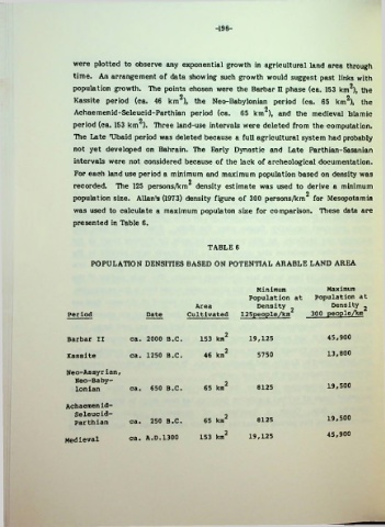
were plotted to observe any exponential growth in agricultural land area through
time. An arrangement of data showing such growth would suggest past links with
population growth. The points chosen were the Barbar n phase (ca. 153 km2), the
Kassite period (ca. 46 km2), the Neo-Babylonian period (ca. 65 km2), the
P
Achaemenid-Seleucid-Parthian period (ca. 65 km ), and the medieval Islamic
period (ca. 153 km ). Three land-use intervals were deleted from the computation.
The Late TJbaid period was deleted because a full agricultural system had probably
not yet developed on Bahrain. The Early Dynastic and Late Parthian-Sasanian
intervals were not considered because of the lack of archeological documentation.
For each land use period a minimum and maximum population based on density was
2
recorded. The 125 persons/km density estimate was used to derive a minimum
2
population size. Allan's (1973) density figure of 300 persons/km for Mesopotamia
was used to calculate a maximum populaton size for comparison. These data are
presented in Table 6.
TABLE 6
POPULATION DENSITIES BASED ON POTENTIAL ARABLE LAND AREA
Minimum Maximum
Population at Population at
Area Density 2 Density 2
Period Date Cultivated 125people/kin 300 people/km
Barbar II ca. 2000 B.C. 153 km2 19,125 45,900
Kassite ca. 1250 B.C. 46 km2 5750 13,800
Neo-Assyrian,
Neo-Baby
lonian ca. 650 B.C. 65 km2 8125 19,500
Achaemenid-
Seleucid- 19,500
Parthian ca. 250 B.C. 65 km2 8125
Medieval ca. A.D.1300 153 km2 19,125 45,900