
Page 27 - Redditch SuDS DESIGN & EVALUATION
P. 27
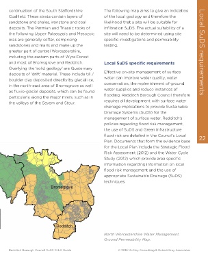
continuation of the South Staffordshire                The following map aims to give an indication
      Coalfield. These strata contain layers of              of the local geology and therefore the
      sandstone and shales, ironstone and coal               likelihood that a site will be suitable for
      deposits. The Permian and Triassic rocks of            infiltration SuDS. The actual suitability of a
      the following Upper Palaeozoic and Mesozoic            site will need to be determined using site
      eras are generally softer, comprising                  specific investigations and permeability
      sandstones and marls and make up the                   testing.
      greater part of central Worcestershire,                                                                      Local SuDS requirements
      including the eastern parts of Wyre Forest

      and most of Bromsgrove and Redditch.                   Local SuDS specific requirements
      Overlying the ‘solid geology’ are Quaternary
      deposits of ‘drift’ material. These include till /     Effective on-site management of surface
      boulder clay deposited directly by glacial ice,        water can improve water quality, water
      in the north-east area of Bromsgrove as well           conservation, the replenishment of ground
      as fluvio-glacial deposits, which can be found         water supplies and reduce instances of
      particularly along the major rivers, such as in        flooding. Redditch Borough Council therefore
      the valleys of the Severn and Stour.                   requires all development with surface water
                                                             drainage implications to provide Sustainable
                                                             Drainage Systems (SuDS) for the
                                                             management of surface water. Redditch’s
                                                             policies regarding flood risk management,

                                                             the use of SuDS and Green Infrastructure
                                                             flood risk are detailed in the Council’s Local        22
                                                             Plan. Documents that form the evidence base
                                                             for the Local Plan include the Strategic Flood
                                                             Risk Assessment (2012) and the Water Cycle
                                                             Study (2012) which provide area specific
                                                             information regarding information on local
                                                             flood risk management and the use of
                                                             appropriate Sustainable Drainage (SuDS)
                                                             techniques.


                                                             North Worcestershire Water Management
                                                             Ground Permeability Map.


      Redditch Borough Council SuDS D & E Guide                                                        © 2018 McCloy Consulting & Robert Bray Associates