
Page 27 - Croydon
P. 27
6.0 Local SuDS requirements for Norbury Brook which feeds into the River Flood Risk Areas in the Borough
Local SuDS requirements
Wandle further downstream. The south
The main areas of fluvial flood risk in the
Croydon
eastern part of the Borough, including the
settlements of Forestdale and Addington, is
Strategic Flood Risk Assessment (SFRA) and
characterised by steeper topography and Borough, as illustrated in the Croydon
Landscape Character more rural land which drains into the in the Local Flood Risk Management Strategy
tributaries of the River Ravensbourne which (LFRMS), are located along Godstone Road
The London Borough of Croydon is located in in Kenley and Purley (associated with the
flow north eastwards into the London
the south of Greater London and covers an Borough of Bromley. Caterham Bourne), along Brighton Road Local SuDS requirements
area of approximately 86km2. It is bounded south of the Purley Cross roundabout and
to the north by the London Boroughs of Local Geology around Wandle Park (associated with the
Merton and Lambeth, to the east by the culverted River Wandle), areas in the vicinity
The underlying bedrock of the London
London Borough of Bromley, to the west by of the Norbury Brook along Thornton Heath
the London Borough of Sutton and to the Borough of Croydon is Middle and Upper and Norbury and areas in South Norwood
Chalk in the south, which is overlain by
south by Tandridge District and Reigate and Country Park and Shirley (associated with
Banstead Borough in Surrey. The Borough is Thanet Sand Formation (fine sand), Lambeth the Chaffinch Brook).
Group (clay and sand), Harwich Formation
characterised by steep slopes in Coulsdon in
the south which level off to flatter land in the (sand and flint) and the London Clay Group The main areas of surface water flooding are
in the north. The bedrock and drift geology in located in Purley Town Centre, Purley Cross,
north. Brighton Road is located in the natural
valley of the River Wandle, now entirely the borough are illustrated in the map above. Kenley Station, Brighton Road at Coulsdon,
Further information on the geology of the Purley Oaks Road and Station, Norbury and
culverted until it emerges at Wandle Park in
South Croydon. borough can be found in the British Thornton Heath. Additionally, during August
Geological Survey (BGS) website. 2015 severe flooding also affected the areas
21 The Borough is generally urbanised along the along Kenley, Coulsdon and New Addington. 22
main transport corridors (A23, A232 and Local Drainage and Sewer Network During June 2016, the area along Caterham
railway) and in the north of the Borough, with
Geological Survey The waste water drainage infrastructure in
the main urban centres located in Central and
Solid the north of the Borough is generally a
South Croydon, Thornton Heath and Purley. Chalk-Middle separate surface and foul sewer system, with
With increasing distance from the Croydon Chalk- Upper combined sewer systems in small areas of
Metropolitan Centre and the Brighton Road Claygate Sand
Harwich Sand Upper Norwood and Waddon. Thames
corridor, development begins to open out Lambeth Sand and Clay Water is responsible for receiving surface
with more park and rural land in the south of London Clay water from developments in the north of the
the Borough around Coulsdon and New Thanet Sand
Drift Borough which discharge via the adopted
Addington. Aluvium sewers.
Clay with Flints
The Borough contains five main rivers; River Hackney Gravel In the south of the Borough there is no
Wandle, Caterham Bourne, Merstham Bourne, Head- Clay/Silt surface water sewer system. The area is
Norbury Brook and Chaffinch Brook. The Head- Gravel
Kempton Park Gravel generally served by soakaways with the
majority of the Borough drains into the Artifi cial Deposits highway drained by a series of interlinked
catchment of the River Wandle, which passes Bedrock and drift
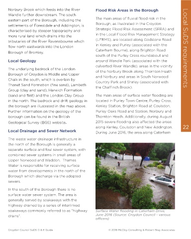
geology (Source: soakaways commonly referred to as “highway Surface Water fl ooding in Caterham Drive,
into the London Borough of Sutton. The London Borough of drains”. June 2016 (Source: Croydon Council - various
northern part of the Borough drains into the Croydon) offi cers)
Croydon Council SuDS D & E Guide © 2018 McCloy Consulting & Robert Bray Associates Croydon Council SuDS D & E Guide © 2018 McCloy Consulting & Robert Bray Associates