
Page 24 - High Knob Master Plan
P. 24
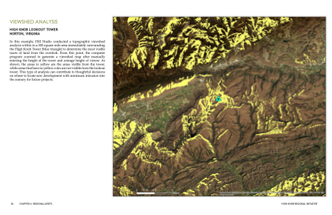
 VIEWSHED ANALYSIS
HIGH KNOB LOOKOUT TOWER NORTON, VIRGINIA
In this example, Hill Studio conducted a topographic viewshed analysis within in a 300 square mile area immediately surrounding the High Knob Tower (blue triangle) to determine the most visible tracts of land from the overlook. From this point, the computer program scanned to generate a viewshed map after manually entering the height of the tower and average height of viewer. As shown, the areas in yellow are the areas visible from the tower, while areas that have no yellow color are not visible from the lookout tower. This type of analysis can contribute to thoughtful decisions on where to locate new development with minimum intrusion into the scenery for future projects.
24 CHAPTER 4: REGIONAL ASSETS
HIGH KNOB REGIONAL INITIATIVE
