
Page 82 - The Age of Sultan Suleyman the Magnificent
P. 82
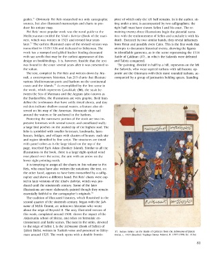
guides. 71  Obviously  Piri  Reis  researched  not  only  cartographic  piece  of which  only  the  left  half remains.  In  it the  author,  sit-
    sources,  but  also  illustrated manuscripts and  charts to  pro-  ting  under  a  tent,  is accompanied  by two  calligraphers;  the
    duce  his unique  map.                                     right  half must  have  shown  Selim  I and  his  court.  The re-
      Piri  Reis'  most  popular  work  was  the  naval guide  to  the  maining  twenty-three illustrations begin  the  pictorial  narra-
    Mediterranean  entitled the  Kitab-i  Bahriye  (Book of the mari-  tion  with  the  enthronement  of Selim and  conclude  it with  his
    ner),  which  was  written  in  1521  and  revised  four  years  death.  Executed  by  two  similar hands,  they  reveal  influences
    later. 72  The  earliest illustrated copy  of the  revised  version  was  from  Herat  and  possibly  even  Cairo. This is the  first  work  that
    transcribed  in  1525/1526  and  dedicated  to  Suleyman.  The  attempts  to document  historical  events,  showing  the figures
    work  has  a  stamped  and  gilded leather  binding  decorated  in  identifiable garments,  as in  the  scene  representing  the  1514
    with  saz scrolls that  may  be  the  earliest appearance  of this  Battle  of Çaldiran  (37), in  which  the  Safavids were  defeated
    design  on  bookbindings.  It is, however,  feasible that  the  text  and  Tabriz  conquered.
    was  bound  in  the  court  several  years  after  it was  presented  to  The  painting,  divided  in  half by  a  hill, represents  on  the  left
    the sultan.                                                the  Safavids, who  wear  tapered  turbans  with  tall batons;  op-
      The  text,  compiled  by  Piri  Reis and  written  down  by Mu-  posite  are  the  Ottomans  with  their  more  rounded  turbans,  ac-
    radi,  a  contemporary  historian, has  215  charts  that illustrate  companied  by  a  group  of janissaries holding  spears.  Standing
    various Mediterranean  ports  and  harbors  on  the continental
    coasts  and  the  islands. 73  As exemplified by  the  first  scene  in
    the  work,  which  represents  Çanakkale (36),  the  strait be-
    tween  the  Sea of Marmara  and  the  Aegean  (also known  as
    the  Dardanelles), the  illustrations are  very graphic.  Bold  lines
    define  the  landmasses that  have  softly  tinted  shores,  and  tiny
    red  dots  indicate shallow  coastal  waters,  a  feature  also  ob-
    served  on  his  map  of the  Americas.  Minuscule  ships sail
    around  the  waters  or  lie anchored  in the  harbors.
      Protecting  the  narrowest  portion  of the  strait are  two  im-
    pressive  fortresses with  several  towers  and  crenellated  walls;
    a  large bird  perches  on  the  peaked  tip  of the  highest  roof.  The
    folio  is sprinkled with  smaller  fortresses, landmarks,  farm-
    houses,  bridges,  and  villages with  clusters of houses,  each  site
    and  region  identified  by  fine  script. The  structures  are  tinted
    with  pastel  colors  as  is the  large  island  on  the  top  of  the
    page,  inscribed  E§ek  Adasi  (Donkey Island). Similar to  all  the
    illustrations  in  the  book,  there  is a  large eight-spoked  wind
    rose  placed  over  the  scene,  the  arm  with  an  arrow  on  the
    lower  right pointing  north.
      It  is tempting  to  assign  all the  charts  in  this  volume  to  Piri
    Reis, who  must  have  also  written  the  notations;  the  text,  on
    the  other hand,  appears to  have  been  transcribed  by  a callig-
    rapher  and  shows  a  different hand.  Piri  Reis'  charts  were  cop-
    ied  in  later  versions  of the  Kitab-i Bahriye,  which  was  pro-
    duced  until  the  nineteenth  century.  Some of the  later
    illustrations  are  more  elaborately  painted  though  they  remain
    essentially  faithful  to  the  cartographer's  originals. 74
      The tradition  of illustrated  histories,  which  flourished  in  the
    second  quarter  of the  sixteenth  century,  began  with  the  §ah-
    name of Melik  Ümmü,  an  unknown  historian  who  wrote
    about  the  reign  of Bayezid  II. The  only  illustrated  version  of
    this work,  completed  around  1500,  shows the  impact  of the
    Akkoyunlu  school  of Shiraz,  and  relies  on  formulaic  en-
    thronement  and  battle  scenes. The next  in the  series,  devoted
    to  the  reign  of  Selim  I,  is the  Selimname  (Book  of  Selim)  of
    §ukru  Bitlisi, written  in Turkish  verse  and  presented  to Suley-  37.  Sultan  Selim  I at  the  Battle of Çaldiran from  the  Selimname of §ükrü
    man  around  1525. The work  opens with  a  double  frontis-  Bitlisi,  c.  1525  (Istanbul, Topkapi  Sarayí  Müzesi,  H.  1597-1598,  fol.  113a)

                                                                                                                    81