
Page 285 - Edo: Art in Japan, 1615–1868
P. 285
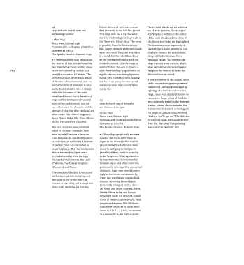
Hi                              Dishes decorated  with map scenes  The stylized  islands are set within a
                         Large dish with map  of Japan  and  date primarily to the late Edo period.  sea of wave patterns. "Great Japan"
                         surrounding countries           This large dish has  a six-character  (Dai Nippon) is written in the  center
                                                         mark in the footring reading "made in  of the main island, and the  cities of
                         c. 1830/1843
                                                                                          Edo, Kyoto, and
                                                                                                      Osaka are
                                                                                                              highlighted.
                         Hizen ware, Koimari style       the Tenpó era" (1830 -1843). The piece  The domains  are not separately  de-
                                                                      the
                                                                  from
                                                         is possibly
                                                                         Tataranomoto
                         Porcelain with underglaze cobalt blue  kiln, where similarly patterned  sherds
                                    7
                         Diameter 48 (i8 /s)             were excavated. The plate was made  lineated, but  a white Mount Fuji  can
                                                                                          clearly be seen
                                                                                                     on the main island,
                         The Kyushu Ceramic Museum, Saga
                                                         in a mold, but the cobalt blue lines  along with  Lake Biwa and  three
                         •  A large horizontal map of Japan on  do not correspond exactly with  the  mountain ranges. The exterior dis-
                         the interior of this dish is framed by  molded contours. Like the  maps on  plays a simple  wave pattern,  which
                         two large flying cranes and six cloud  similar dishes, this  one is done in a  plays against the islands  and water
 284                     bands surrounded by islands  and  style developed by Gyôgi Bosatsu, an  design on the interior to make  the
                         partial landmasses,  all labeled. The  eighth-century wandering Japanese  dish itself into an island.
                         northern  section  of the main island  monk, who is credited with drawing
                         of Honshu is foreshortened, and  the  the first map to rely on conceptual  A new awareness  of the  outside world
                                                                                             a concomitant growing sense of
                                                                                          and
                         northern island of Hokkaido is only  distances  rather than cartographic
                         partly depicted. Lake Biwa is clearly  verity. NCR               nationhood, perhaps encouraged by
                                                                                          sightings  of American and Russian
                         visible in the center of the  main                               ships, made such  dishes  attractive to
                         island, and Mount Fuji is drawn as a                             consumers.  Large plates of this kind
                         large outline. Contiguous boundary  142
                         lines define  each domain, and dis-  Large dish with map  of the world  were originally made for the  domestic
                                                                                                           found at the
                                                                                          market; similar sherds
                         tances between  the domains and the  and  distances from  Japan  Kamanotani kiln site in Arita suggest
                         amount of rice that they produced are
                         often  noted. The cities of Nagasaki,  c.1830/1843               the  origin of this porcelain, marked was
                                                         Hizen ware, Koimari style
                                                                                          "made in the Tenpô era." The dish
                         Kyoto, Osaka, Sakai, Edo, Oshu, Mimai-  Porcelain with underglaze cobalt blue  formed  in a mold, with molded relief
                         ya, and Hakodate are indicated.               3
                                                          Diameter 52.8 (20 A)            lines, but the cobalt blue painting
                         The last two cities were relatively  The Kyushu Ceramic Museum, Saga  does not  align precisely. NCR
                         small at this time but might  have
                         been included because  a ferry ran  •  Although geographically accurate
                         from  Mimaiya (in northern Honshu)  maps of the world were made in
                         to Hakodate (in Hokkaido). The most  Japan in the  second half of the Edo
                         important cities  are connected by  period, deliberate distortions were
                         major highways. The four  landmasses  made in cartographic designs on
                         shown surrounding Japan are —    porcelain dishes, made in quantity
                         in clockwise order from  the  top —  in the Tenpô era. What appeared to
                         the  Land of the  Dwarves, the  Land  be important was the  relationship
                         of Women, the  Ryukyu Kingdom    between Japan and other countries,
                         (Okinawa), and  Korea.           particularly with regard to conceptual
                                                          distances. Japan was placed reassur-
                         The exterior of the  dish is decorated  ingly at the center, surrounded by
                         with  a wave pattern  (carrying over  water and islands and various land-
                         the motif of the  ocean from  the  masses. Revolving around Japan
                         interior of the  dish), and  a simplified  (not overly enlarged) on this  dish
                         lotus motif encircles  the footring.
                                                          are South and North America, Korea,
                                                          Russia, China, India, and  Europe.
                                                          Imaginary lands are depicted  as well:
                                                          those  of dwarves, white people, black
                                                          people, and women. The distances
                                                          from  these  countries to Japan, mea-
                                                          sured in ri (i ri = 3.9 km), are  written
                                                          in a cartouche to the  right of Japan.