
Page 35 - The Black Range Naturalist Vol. 4, No. 3
P. 35
The amount of soil moisture is only one indicator of the crisis we face. The state of our surface water and associated riparian zones is another.
There are a number of factors which affect the flow of water above ground level and through the strata below. The interplay between the amount and timing of water intake (snow melt and rainfall), the topography of the surface the precipitation falls on and flows over, the type and amount of vegetative cover, the physical and chemical characteristics of the ground the precipitation falls on, air and ground temperature, and the physical and chemical characteristics of the underlying strata are a few of the factors which determine the amount of surface water which is present at any particular site.
In “Widespread potential loss of streamflow into underlying aquifers across the USA” (Jasechko, Seybold, Perrone, Fan, and Kirchner; Nature; Vol. 591, 18 March 2021; pp 391-395), the authors surveyed the likelihood of, and the amount of, surface water percolating downward to underlying aquifers throughout the United States.
There are two “common sense” principles which most would immediately recognize: there is a
tendency of water to soak into the ground, and the nature of the ground is a determining factor in the rate and amount of absorption. Add to these two the importance of the amount and level of water in the strata below ground. Our understanding of how this water exchange works is bifurcated between broad brush studies of large geographic areas and very specific studies of very narrowly defined geographic areas.
Both extremes suffer from deficiencies in data. Our lack of understanding about what is happening in more narrowly defined areas (e.g. watersheds in the case of small site studies) and our lack of understanding at larger scales (in the case of regional and national studies) is often unappreciated. This study adds information to our understanding of everything in between - albeit an incomplete understanding, but a start.
Watercourses which lose water to underlying aquifers are referred to as losing streams, those that gain water from aquifers are called gaining streams in the study. Our area is characterized by losing streams. To determine if streams were likely to be gaining or losing, the authors compiled and analyzed data from millions of wells located in proximity to watercourses. If the static level of water in the well was higher than the elevation of the stream, the stream was likely to be “gaining”; if
lower, the stream was likely to be “losing”. A simple and effective model but one which is affected by the nature of rock formations which exist between stream level and the static level of the wells.
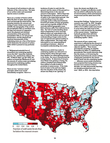
Among their findings, “losing rivers are common near wells” (p. 393). Roughly 2/3 of the wells they surveyed (or 4.2 million of 6.3 million wells) were found in areas where the static level of the water in a well was below the elevation of the nearest stream, “implying a hydraulic gradient that will drive seepage from the channel into the underlying aquifer.” (Ibid.)
The amount of loss a steam may experience is affected by the amount of water pumping which is occurring from adjacent aquifers. “Near-stream groundwater pumping can deplete streamflow by either (1) withdrawing groundwater that would otherwise seep into the stream, or (2) lowering the hydraulic head below the stream surface, creating the potential for the stream itself to drain into the underlying aquifer . . . . Whereas recent model simulations have projected that losing streams may become more common in future decades, our data demonstrate that they are already prevalent here and
now.” (Ibid., p. 394). See map below.
34
