
Page 11 - Geologic Investigations in the Lake Valley Area, Sierra County, New Mexico
P. 11
108°
33°30'
33°
32°30'
180
107° 106° SIERRA COUNTY
Alamogordo
107°37'30" 32°52'30"
107°30'
KH
Plate 1 152
27
LV
61
27
z
McClede Mtn
25
Elephant Butte Reservoir
Truth or Consequences
70
26
Las Cruces
54
NEW MEXICO
TEXAS
10
32°
70
z Deming
NEW
MEXICO
UNITED STATES MEXICO
El Paso
Berrenda Mtn
Area of plate 1
O Bar O Peak
10 32°45'
z 27
NEW MEXICO Sierra County
0
0
30 KILOMETERS
20 MILES
Apache Town Lake Hill
Mtn Valley
Monument Peak
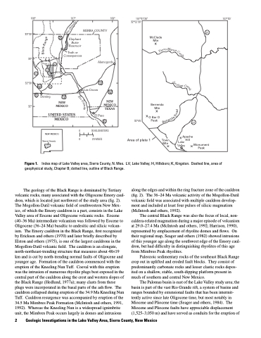
Figure 1.
Index map of Lake Valley area, Sierra County, N. Mex. LV, Lake Valley; H, Hillsboro; K, Kingston. Dashed line, area of geophysical study, Chapter B; dotted line, outline of Black Range.
The geology of the Black Range is dominated by Tertiary volcanic rocks, many associated with the Oligocene Emory caul dron, which is located just northwest of the study area (fig. 2). The Mogollon-Datil volcanic field of southwestern New Mex ico, of which the Emory cauldron is a part, consists in the Lake Valley area of Eocene and Oligocene volcanic rocks. Eocene (40–36 Ma) intermediate volcanism was followed by Eocene to Oligocene (36–24 Ma) basaltic to andesitic and silicic volcan ism. The Emory cauldron in the Black Range, first recognized by Ericksen and others (1970) and later briefly described by Elston and others (1975), is one of the largest cauldrons in the Mogollon-Datil volcanic field. The cauldron is an elongate, north-northeast-trending structure that measures about 48×19 km and is cut by north-trending normal faults of Oligocene and younger age. Formation of the cauldron commenced with the eruption of the Kneeling Nun Tuff. Coeval with this eruption was the intrusion of numerous rhyolite plugs best exposed in the central part of the cauldron along the crest and western slopes of the Black Range (Hedlund, 1977a); many clasts from these plugs were incorporated in the basal parts of the ash flow. The cauldron collapsed during eruption of the 34.9 Ma Kneeling Nun Tuff. Cauldron resurgence was accompanied by eruption of the 34.5 Ma Mimbres Peak Formation (McIntosh and others, 1991, 1992). Whereas the Kneeling Nun is a widespread ignimbrite unit, the Mimbres Peak occurs largely in domes and intrusions
along the edges and within the ring fracture zone of the cauldron (fig. 2). The 36–24 Ma volcanic activity of the Mogollon-Datil volcanic field was associated with multiple cauldron develop ment and included at least four pulses of silicic magmatism (McIntosh and others, 1992).
The central Black Range was also the focus of local, non- caldera-related magmatism during a major episode of volcanism at 29.0–27.4 Ma (McIntosh and others, 1992; Harrison, 1990), represented by emplacement of rhyolite domes and flows. On their regional map, Seager and others (1982) showed intrusions of this younger age along the southwest edge of the Emory caul dron, but had difficulty in distinguishing rhyolites of this age from Mimbres Peak rhyolites.
Paleozoic sedimentary rocks of the southeast Black Range crop out in uplifted and eroded fault blocks. They consist of predominantly carbonate rocks and lesser clastic rocks depos ited on a shallow, stable, south-dipping platform present in much of southern and central New Mexico.
The Palomas basin is east of the Lake Valley study area; the basin is part of the vast Rio Grande rift, a system of basins and ranges bounded by extensional faults that has been intermit tently active since late Oligocene time, but most notably in Miocene and Pliocene time (Seager and others, 1984). The Miocene and Pliocene faults have appreciable displacement (1,525–3,050 m) and have served as conduits for the eruption of
2 Geologic Investigations in the Lake Valley Area, Sierra County, New Mexico
e
d
n
a
r
G
o
i
R
e
g
n
a
R
k
a
r
r
e
i
T
B
l
a
n
c
a
lac
C
B
r
e
e
k
J
a
a
r
a
l
o
C
s
r
e
e
k
Rio
G
r
a
n
d
e
d
a
o
R
a
d
n
e
r
r
e
B
