
Page 30 - Geologic Investigations in the Lake Valley Area, Sierra County, New Mexico
P. 30
108° 107°45' 33°
107°30'
107°15'
2
3
7
8
1
LV
Plate 1
56
9
10
4
12
11
32°45'
380.0 280.0 220.0 200.0 180.0 140.0 120.0 100.0
80.0 60.0 40.0 20.0
0.0 -20.0 -40.0 -60.0 -80.0 -100.0 -120.0 -140.0 -160.0 -180.0 -200.0 -220.0 -260.0
Nanotesla (nT)
32°30'
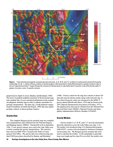
Figure 1.
proportional to depth of source (Bankey and Kleinkopf, 1988). The traces of gradient midpoint (maxima) of the horizontal mag netic gradient (fig. 2) were calculated and plotted on the residual aeromagnetic anomaly map in order to enhance anomalies for geologic interpretation. The plots (fig. 2) help delineate magne tization boundaries (Cordell and Grauch, 1985) that may signify geologic contacts or linear geologic features.
Gravity Data
The complete Bouguer gravity anomaly map was compiled from nonproprietary data obtained from the National Imagery and Mapping Agency (NIMA). During field work in September 1996, 11 new gravity stations were read in the Lake Valley area to better constrain the gravity interpretations. The reference base used was DOD 3918-1 located at the Truth or Conse quences Post Office. The gravity data were reduced using stan dard USGS procedures described by Bankey and Kleinkopf
15 KILOMETERS
0
5
10
Total-intensity aeromagnetic anomaly map reduced to pole. A–A', B–B', and C–C', profiles of crustal sections derived from gravity models (figs. 4, 5, 6). 1, outline of Emory cauldron; 2, Animas graben; 3, Berrenda fault; 4, Santa Rita lineament; 5, granitic intrusive rocks; 6, trace of regional thrust fault; 7, Copper Flat granitic intrusion; 8, Palomas basin; 9, Lake Valley fault; 10, granitic rocks of Rio Grande uplift; 11, graben of volcanic rocks, 12, granitic intrusion.
22 Geologic Investigations in the Lake Valley Area, Sierra County, New Mexico
(1988). Gravity control for the map area consists of about 329 unevenly spaced stations mainly along roads and trails (fig. 3). The observed gravity values are referenced to the IGSN-71 gravity datum (Morelli and others, 1974) and are based on the 1967 ellipsoid (International Association of Geodesy, 1971). The digital gravity data may be obtained from the National Geo physical Data Center (NGDC), National Oceanic and Atmo spheric Administration (NOAA), Boulder, CO 80303.
Gravity Models
Gravity models A–A′, B–B′, and C–C′ provide information about the subsurface across the Lake Valley area (figs. 4–6). The models were produced using a 2.0-dimensional program (GM-SYSTM, version 4.04) developed by Northwest Geophysi cal Associates, Inc. The Bouguer gravity anomaly data were used to calculate the models. As the topography is generally long wave length and less than 90 m in relief, the models were
C–C'
A–A'
B–B'
