
Page 32 - Geologic Investigations in the Lake Valley Area, Sierra County, New Mexico
P. 32
33°
108°
107°45'
107°30' 107°15'
7
3 2
5
8
1
4
9
10
12
11
6
32°45'
-158.0 -160.0 -162.0 -164.0 -166.0 -168.0 -170.0 -172.0 -174.0 -176.0 -178.0 -180.0 -182.0 -184.0 -186.0 -188.0 -190.0 -192.0 -194.0 -196.0 -198.0 -200.0 -202.0 -204.0 -208.0 -210.0 -212.0
Milligals
32°30'
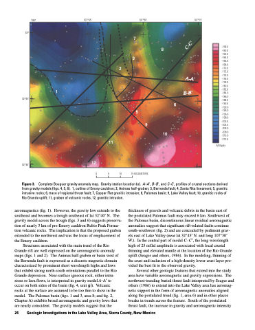
Figure 3.
aeromagnetics (fig. 1). However, the gravity low extends to the southeast and becomes a trough southeast of lat 32°40′ N. The gravity model across the trough (figs. 3 and 6) suggests preserva tion of nearly 3 km of pre-Emory cauldron Rubio Peak Forma tion volcanic rocks. The implication is that the proposed graben extended to the northwest and was the locus of emplacement of the Emery cauldron.
Structures associated with the main trend of the Rio Grande rift are well expressed on the aeromagnetic anomaly maps (figs. 1 and 2). The Animas half-graben or basin west of the Berrenda fault is expressed as a discrete magnetic domain characterized by prominent short wavelength highs and lows that exhibit strong north-south orientations parallel to the Rio Grande depression. Near-surface igneous rock, either intru sions or lava flows, is interpreted in gravity model A–A′ to occur on both sides of the basin (fig. 4, unit gi). Volcanic rocks at the surface are assumed to be too thin to show in the model. The Palomas basin (figs. 1 and 3, area 8; and fig. 2, Chapter A) exhibits broad aeromagnetic and gravity lows that are nearly coincident. The gravity models suggest that the
15 KILOMETERS
0 5 10
Complete Bouguer gravity anomaly map. Gravity station location (o). A–A', B–B', and C–C', profiles of crustal sections derived from gravity models (figs. 4, 5, 6). 1, outline of Emory cauldron; 2, Animas half-graben; 3, Berrenda fault; 4, Santa Rita lineament; 5, granitic intrusive rocks; 6, trace of regional thrust fault; 7, Copper Flat granitic intrusion; 8, Palomas basin; 9, Lake Valley fault; 10, granitic rocks of Rio Grande uplift; 11, graben of volcanic rocks, 12, granitic intrusion.
24 Geologic Investigations in the Lake Valley Area, Sierra County, New Mexico
thickness of gravels and volcanic debris in the basin east of the postulated Palomas fault may exceed 6 km. Southwest of the Palomas basin, discontinuous linear residual aeromagnetic anomalies suggest that significant rift-related faults continue south-southwest (fig. 2) and are concealed by pediment grav els east of Lake Valley (near lat 32°45′ N. and long 107°30′ W.). In the central part of model C–C′, the long wavelength high of 25 mGal amplitude is associated with local crustal thinning and elevated mantle at the location of the Rio Grande uplift (Seager and others, 1986). In the modeling, thinning of the crust and inclusion of a high-density lower crust layer pro vided the best fit to the observed gravity.
Several other geologic features that extend into the study area have variable aeromagnetic and gravity expressions. The northwest-trending buried thrust fault interpreted by Seager and others (1986) to extend into the Lake Valley area has aeromag netic support in the form of aeromagnetic anomalies aligned along the postulated trend (fig. 1, area 6) and in other places breaks in trends across the feature. South of the postulated thrust fault, the increase in gravity and aeromagnetic intensity
C–C'
A–A'
B–B'
