
Page 34 - Geologic Investigations in the Lake Valley Area, Sierra County, New Mexico
P. 34
375
Observed
-25
-425
-165
-190
-215 0
25
WSW fault
fault
Lake Valley fault
Palomas basin fault ENE
Observed Calculated
v1 v2 v3 gi gravel D=2.5 D=2.4 D=2.5 D=2.5 Uc D=2.4
D=2.7
Mc D=2.85
Lc D=2.9
mantle D=3.2
50
0 25 50
DISTANCE, IN KILOMETERS
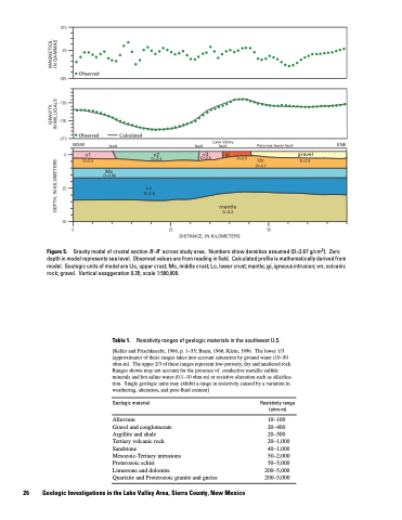
Gravity model of crustal section B–B' across study area. Numbers show densities assumed (D=2.67 g/cm3). Zero depth in model represents sea level. Observed values are from reading in field. Calculated profile is mathematically derived from model. Geologic units of model are Uc, upper crust; Mc, middle crust; Lc, lower crust; mantle; gi, igneous intrusion; vn, volcanic rock; gravel. Vertical exaggeration 0.35; scale 1:500,000.
Table 1. Resistivity ranges of geologic materials in the southwest U.S.
[Keller and Frischknecht, 1966, p. 1–55; Brant, 1966; Klein, 1996. The lower 1/3 (approximate) of these ranges takes into account saturation by ground water (10–50 ohm-m). The upper 2/3 of these ranges represent low-porosity, dry and unaltered rock. Ranges shown may not account for the presence of conductive metallic sulfide minerals and hot saline water (0.1–10 ohm-m) or resistive alteration such as silicifica tion. Single geologic units may exhibit a range in resistivity caused by a variation in weathering, alteration, and pore-fluid content]
Figure 5.
Geologic material
Alluvium
Gravel and conglomerate
Argillite and shale
Tertiary volcanic rock
Sandstone
Mesozoic-Tertiary intrusions
Proterozoic schist
Limestone and dolomite
Quartzite and Proterozoic granite and gneiss
Resistivity range (ohm-m)
10–100 20–400 20–500 20–1,000 40–1,000 50–2,000 50–5,000
200–5,000 200–5,000
26 Geologic Investigations in the Lake Valley Area, Sierra County, New Mexico
GRAVITY, MAGNETICS, DEPTH, IN KILOMETERS IN MILLIGALS IN GAMMAS
