
Page 35 - Geologic Investigations in the Lake Valley Area, Sierra County, New Mexico
P. 35
375
175
-25
-225
-425 -150
-160 -170 -180 -190 -200
0
25
50
Observed
Observed
SW
Calculated
fault
graben
fault v3
Lake Valley fault AMT high
gi v3
Palomas basin fault
v5 NE
gi D=2.75
v2 D=2.4
D=2.5
mantle D=3.2
D=2.5
D=2.55 D=2.5
Lc D=2.9
D=2.45
gravel D=2.4
Mc D=2.85
Uc D=2.67
0 25 50
DISTANCE, IN KILOMETERS
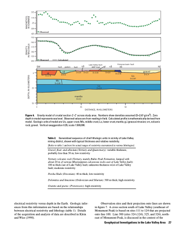
Gravity model of crustal section C–C' across study area. Numbers show densities assumed (D=2.67 g/cm3). Zero depth in model represents sea level. Observed values are from reading in field. Calculated profile is mathematically derived from model. Geologic units of model are Uc, upper crust; Mc, middle crust; Lc, lower crust; mantle; gi, igneous intrusion; vn, volcanic rock; gravel. Vertical exaggeration 0.35; scale 1:500,000.
Table 2. Generalized sequence of chief lithologic units in vicinity of Lake Valley mining district, shown with typical thickness and relative resistivity.
[Refer to table 1 and text for actual ranges of resistivity encountered in various lithologies]
Gravel, float and alluvium (Tertiary and Quaternary): variable thickness, probably less than 30 m; low resistivity
Tertiary volcanic rock (Tertiary, mainly Rubio Peak Formation, lumped with about 20 m of various Mississippian calcareous rocks east of Lake Valley fault): 100 m thick east of Lake Valley fault; unknown thickness west of Lake Valley fault; moderate resistivity
Percha Shale (Devonian): 40 m thick; low resistivity
Dolomites and limestone (Ordovician and Silurian): 300 m thick; high resistivity Granite and gneiss (Proterozoic): high resistivity
Figure 6.
electrical resistivity versus depth in the Earth. Geologic infer- ences from this information are based on the relationships between electrical resistivity and lithology (table 1). Details of the acquisition and analysis of data are described in Klein and Wise (1998).
Observation sites and their projection onto lines are shown in figure 7. A cross section south of Lake Valley (southeast of Monument Peak) is based on sites 111 to 124 that are projected onto line 100. Line 300 (sites 324 (124), 325, and 326), north- east of Monument Peak, is discussed in the context of the
Geophysical Investigations in the Lake Valley Area 27
GRAVITY, MAGNETICS, DEPTH, IN KILOMETERS IN MILLIGALS IN GAMMAS
