
Page 33 - Geologic Investigations in the Lake Valley Area, Sierra County, New Mexico
P. 33
375
Observed
75
-425
-170
-195
-220 0
25
WEST Emory cauldron
Lake Valley fault gi
Berrenda
vc fault gi Palomas basin fault EAST
Observed Calculated
v1
D=2.5
v2
D=2.45
v3
D=2.5
D=2.6
D=2.45
mantle D=3.28
D=2.6
gravel gi D=2.45
D=2.7
Mc D=2.85
Uc
D=2.67
Lc D=2.9
50
0 25 50
DISTANCE, IN KILOMETERS
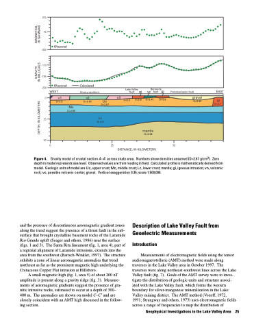
Gravity model of crustal section A–A' across study area. Numbers show densities assumed (D=2.67 g/cm3). Zero depth in model represents sea level. Observed values are from reading in field. Calculated profile is mathematically derived from model. Geologic units of model are Uc, upper crust; Mc, middle crust; Lc, lower crust; mantle; gi, igneous intrusion; vn, volcanic rock; vc, possible volcanic center; gravel. Vertical exaggeration 0.35; scale 1:500,000.
Figure 4.
and the presence of discontinuous aeromagnetic gradient zones along the trend suggest the presence of a thrust fault in the sub- surface that brought crystalline basement rocks of the Laramide Rio Grande uplift (Seager and others, 1986) near the surface (figs. 1 and 3). The Santa Rita lineament (fig. 1, area 4), part of a regional alignment of Laramide intrusions, extends into the area from the southwest (Bartsch-Winkler, 1997). The structure exhibits a zone of linear aeromagnetic anomalies that trend northeast as far as the prominent magnetic high underlying the Cretaceous Copper Flat intrusion at Hillsboro.
A small magnetic high (fig. 1, area 5) of about 200 nT amplitude is present along a gravity ridge (fig. 3). Measure ments of aeromagnetic gradients suggest the presence of gra nitic intrusive rocks, estimated to occur at a depth of 300– 400 m. The anomalies are shown on model C–C′ and are closely coincident with an AMT high discussed in the follow ing section.
Description of Lake Valley Fault from Geoelectric Measurements
Introduction
Measurements of electromagnetic fields using the tensor audiomagnetotelluric (AMT) method were made along traverses in the Lake Valley area in October 1997. The traverses were along northeast-southwest lines across the Lake Valley fault (fig. 7). Goals of the AMT survey were to inves tigate the distribution of geologic units and structure associ ated with the Lake Valley fault, which forms the western boundary for silver-manganese mineralization in the Lake Valley mining district. The AMT method (Vozoff, 1972, 1991; Strangway and others, 1973) uses electromagnetic fields across a range of frequencies to map the distribution of
Geophysical Investigations in the Lake Valley Area 25
GRAVITY, MAGNETICS, DEPTH, IN KILOMETERS IN MILLIGALS IN GAMMAS
