
Page 31 - Geologic Investigations in the Lake Valley Area, Sierra County, New Mexico
P. 31
32°45'
108°
107°45'
107°30' 107°15'
33°
800.0 700.0 600.0 500.0
400.0 300.0 200.0 100.0 0.0 -100.0 -200.0 -300.0 -400.0 -500.0 -600.0 -700.0 -800.0
Nanotesla (nT)
32°30'
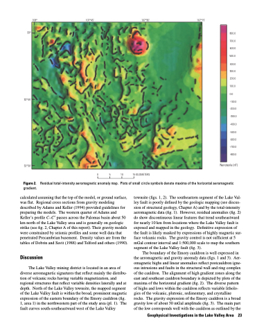
Figure 2.
gradient.
calculated assuming that the top of the model, or ground surface, was flat. Regional cross sections from gravity modeling described by Adams and Keller (1994) provided guidelines for preparing the models. The western quarter of Adams and Keller’s profile C–C′ passes across the Palomas basin about 50 km north of the Lake Valley area and is generally on geologic strike (see fig. 2, Chapter A of this report). Their gravity models were constrained by seismic profiles and some well data that penetrated Precambrian basement. Density values are from the tables of Dobrin and Savit (1988) and Telford and others (1990).
Discussion
The Lake Valley mining district is located in an area of diverse aeromagnetic signatures that reflect mainly the distribu tion of volcanic rocks having variable magnetization, and regional structures that reflect variable densities laterally and at depth. North of the Lake Valley townsite, the mapped segment of the Lake Valley fault is within the broad, prominent magnetic expression of the eastern boundary of the Emory cauldron (fig. 1, area 1) in the northwestern part of the study area (pl. 1). The fault curves south-southeastward west of the Lake Valley
15 KILOMETERS
0 5 10
Residual total-intensity aeromagnetic anomaly map. Plots of small circle symbols denote maxima of the horizontal aeromagnetic
townsite (figs. 1, 2). The southeastern segment of the Lake Val- ley fault is poorly defined by the geologic mapping (see discus sion of structural geology, Chapter A) and by the total-intensity aeromagnetic data (fig. 1). However, residual anomalies (fig. 2) do show discontinuous linear features that trend southeastward for nearly 10 km from locations where the Lake Valley fault is exposed and mapped in the geology. Definitive expression of the fault is likely masked by expressions of highly magnetic sur face volcanic rocks. The gravity control is not sufficient at 5 mGal contour interval and 1:500,000 scale to map the southern segment of the Lake Valley fault (fig. 3).
The boundary of the Emory cauldron is well expressed in the aeromagnetic and gravity anomaly data (figs. 1 and 3). Aer omagnetic highs and linear anomalies reflect postcauldron igne ous intrusions and faults in the structural wall and ring complex of the cauldron. The alignment of high gradient zones along the east and southeast cauldron boundary is depicted by plots of the maxima of the horizontal gradient (fig. 2). The diverse pattern of highs and lows within the cauldron reflects variable litholo gies of the volcanic, plutonic, sedimentary, and crystalline rocks. The gravity expression of the Emory cauldron is a broad gravity low of about 30 mGal amplitude (fig. 3). The main part of the low corresponds well with the cauldron as outlined by the
Geophysical Investigations in the Lake Valley Area 23
