
Page 41 - Geologic Investigations in the Lake Valley Area, Sierra County, New Mexico
P. 41
site 203. Power line signals at 60 Hz and harmonics of those signals can produce deterioration of the signal-to-noise ratio for nearby measurement at frequencies less than a few thousand hertz. Power lines may also carry induced electric currents that distort the electromagnetic response of the Earth.
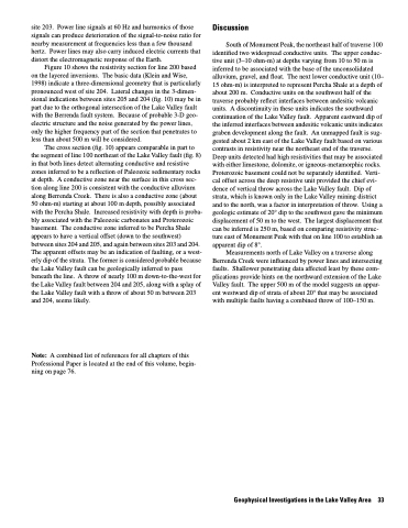
Figure 10 shows the resistivity section for line 200 based on the layered inversions. The basic data (Klein and Wise, 1998) indicate a three-dimensional geometry that is particularly pronounced west of site 204. Lateral changes in the 3-dimen- sional indications between sites 205 and 204 (fig. 10) may be in part due to the orthogonal intersection of the Lake Valley fault with the Berrenda fault system. Because of probable 3-D geo electric structure and the noise generated by the power lines, only the higher frequency part of the section that penetrates to less than about 500 m will be considered.
The cross section (fig. 10) appears comparable in part to the segment of line 100 northeast of the Lake Valley fault (fig. 8) in that both lines detect alternating conductive and resistive zones inferred to be a reflection of Paleozoic sedimentary rocks at depth. A conductive zone near the surface in this cross sec tion along line 200 is consistent with the conductive alluvium along Berrenda Creek. There is also a conductive zone (about 50 ohm-m) starting at about 100 m depth, possibly associated with the Percha Shale. Increased resistivity with depth is proba bly associated with the Paleozoic carbonates and Proterozoic basement. The conductive zone inferred to be Percha Shale appears to have a vertical offset (down to the southwest) between sites 204 and 205, and again between sites 203 and 204. The apparent offsets may be an indication of faulting, or a west erly dip of the strata. The former is considered probable because the Lake Valley fault can be geologically inferred to pass beneath the line. A throw of nearly 100 m down-to-the-west for the Lake Valley fault between 204 and 205, along with a splay of the Lake Valley fault with a throw of about 50 m between 203 and 204, seems likely.
Note: A combined list of references for all chapters of this Professional Paper is located at the end of this volume, begin ning on page 76.
Discussion
South of Monument Peak, the northeast half of traverse 100 identified two widespread conductive units. The upper conduc tive unit (3–10 ohm-m) at depths varying from 10 to 50 m is inferred to be associated with the base of the unconsolidated alluvium, gravel, and float. The next lower conductive unit (10– 15 ohm-m) is interpreted to represent Percha Shale at a depth of about 200 m. Conductive units on the southwest half of the traverse probably reflect interfaces between andesitic volcanic units. A discontinuity in these units indicates the southward continuation of the Lake Valley fault. Apparent eastward dip of the inferred interfaces between andesitic volcanic units indicates graben development along the fault. An unmapped fault is sug gested about 2 km east of the Lake Valley fault based on various contrasts in resistivity near the northeast end of the traverse. Deep units detected had high resistivities that may be associated with either limestone, dolomite, or igneous-metamorphic rocks. Proterozoic basement could not be separately identified. Verti cal offset across the deep resistive unit provided the chief evi dence of vertical throw across the Lake Valley fault. Dip of strata, which is known only in the Lake Valley mining district and to the north, was a factor in interpretation of throw. Using a geologic estimate of 20° dip to the southwest gave the minimum displacement of 50 m to the west. The largest displacement that can be inferred is 250 m, based on comparing resistivity struc ture east of Monument Peak with that on line 100 to establish an apparent dip of 8°.
Measurements north of Lake Valley on a traverse along Berrenda Creek were influenced by power lines and intersecting faults. Shallower penetrating data affected least by these com plications provide hints on the northward extension of the Lake Valley fault. The upper 500 m of the model suggests an appar ent westward dip of strata of about 20° that may be associated with multiple faults having a combined throw of 100–150 m.
Geophysical Investigations in the Lake Valley Area 33
