
Page 40 - Geologic Investigations in the Lake Valley Area, Sierra County, New Mexico
P. 40
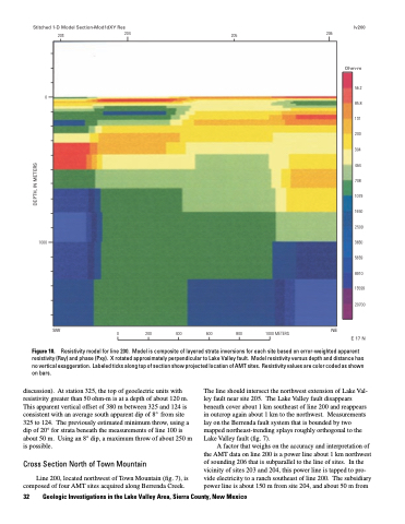
Stitched 1-D Model Section–Mod1dXY Res
lv200
203 204
205
206
         0
Ohm-m
56.2 85.8 131 200 304 464 708 1079 1650 2509 3830 5839 8910 13599 20700
E 17 N
          1000
      SW
Figure 10.
discussion). At station 325, the top of geoelectric units with resistivity greater than 50 ohm-m is at a depth of about 120 m. This apparent vertical offset of 380 m between 325 and 124 is consistent with an average south apparent dip of 8° from site 325 to 124. The previously estimated minimum throw, using a dip of 20° for strata beneath the measurements of line 100 is about 50 m. Using an 8° dip, a maximum throw of about 250 m is possible.
Cross Section North of Town Mountain
Line 200, located northwest of Town Mountain (fig. 7), is composed of four AMT sites acquired along Berrenda Creek.
NE
0
200
400
600
800
1000 METERS
 Resistivity model for line 200. Model is composite of layered strata inversions for each site based on error-weighted apparent resistivity (Rxy) and phase (Pxy). X rotated approximately perpendicular to Lake Valley fault. Model resistivity versus depth and distance has no vertical exaggeration. Labeled ticks along top of section show projected location of AMT sites. Resistivity values are color coded as shown on bars.
32 Geologic Investigations in the Lake Valley Area, Sierra County, New Mexico
The line should intersect the northwest extension of Lake Val- ley fault near site 205. The Lake Valley fault disappears beneath cover about 1 km southeast of line 200 and reappears in outcrop again about 1 km to the northwest. Measurements lay on the Berrenda fault system that is bounded by two mapped northeast-trending splays roughly orthogonal to the Lake Valley fault (fig. 7).
A factor that weighs on the accuracy and interpretation of the AMT data on line 200 is a power line about 1 km northwest of sounding 206 that is subparallel to the line of sites. In the vicinity of sites 203 and 204, this power line is tapped to pro- vide electricity to a ranch southeast of line 200. The subsidiary power line is about 150 m from site 204, and about 50 m from
DEPTH, IN METERS
