
Page 38 - Geologic Investigations in the Lake Valley Area, Sierra County, New Mexico
P. 38
may result in a differential depth to units of about 350 m for each 1 km of separation between the mining area and the AMT sites. Actual locations of the sites, rather than their pro jection to a cross-section line, are considered when account ing for the dip.
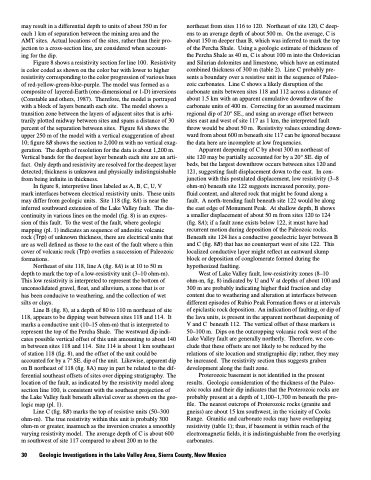
Figure 8 shows a resistivity section for line 100. Resistivity is color coded as shown on the color bar with lower to higher resistivity corresponding to the color progression of various hues of red-yellow-green-blue-purple. The model was formed as a composite of layered-Earth (one-dimensional or 1-D) inversions (Constable and others, 1987). Therefore, the model is portrayed with a block of layers beneath each site. The model shows a transition zone between the layers of adjacent sites that is arbi trarily plotted midway between sites and spans a distance of 30 percent of the separation between sites. Figure 8A shows the upper 250 m of the model with a vertical exaggeration of about 10; figure 8B shows the section to 2,000 m with no vertical exag geration. The depth of resolution for the data is about 1,200 m. Vertical bands for the deepest layer beneath each site are an arti fact. Only depth and resistivity are resolved for the deepest layer detected; thickness is unknown and physically indistinguishable from being infinite in thickness.
In figure 8, interpretive lines labeled as A, B, C, U, V mark interfaces between electrical resistivity units. These units may differ from geologic units. Site 118 (fig. 8A) is near the inferred southward extension of the Lake Valley fault. The dis continuity in various lines on the model (fig. 8) is an expres sion of this fault. To the west of the fault, where geologic mapping (pl. 1) indicates an sequence of andesitic volcanic rock (Trp) of unknown thickness, there are electrical units that are as well defined as those to the east of the fault where a thin cover of volcanic rock (Trp) overlies a succession of Paleozoic formations.
Northeast of site 118, line A (fig. 8A) is at 10 to 50 m depth to mark the top of a low-resistivity unit (3–10 ohm-m). This low resistivity is interpreted to represent the bottom of unconsolidated gravel, float, and alluvium, a zone that is or has been conducive to weathering, and the collection of wet silts or clays.
Line B (fig. 8), at a depth of 80 to 110 m northeast of site 118, appears to be dipping west between sites 118 and 114. It marks a conductive unit (10–15 ohm-m) that is interpreted to represent the top of the Percha Shale. The westward dip indi cates possible vertical offset of this unit amounting to about 140 m between sites 118 and 114. Site 114 is about 1 km southeast of station 118 (fig. 8), and the offset of the unit could be accounted for by a 7° SE. dip of the unit. Likewise, apparent dip on B northeast of 118 (fig. 8A) may in part be related to the dif ferential southeast offsets of sites over dipping stratigraphy. The location of the fault, as indicated by the resistivity model along section line 100, is consistent with the southeast projection of the Lake Valley fault beneath alluvial cover as shown on the geo logic map (pl. 1).
Line C (fig. 8B) marks the top of resistive units (50–300 ohm-m). The true resistivity within this unit is probably 300 ohm-m or greater, inasmuch as the inversion creates a smoothly varying resistivity model. The average depth of C is about 600 m southwest of site 117 compared to about 200 m to the
northeast from sites 116 to 120. Northeast of site 120, C deep- ens to an average depth of about 500 m. On the average, C is about 150 m deeper than B, which was inferred to mark the top of the Percha Shale. Using a geologic estimate of thickness of the Percha Shale as 40 m, C is about 100 m into the Ordovician and Silurian dolomites and limestone, which have an estimated combined thickness of 300 m (table 2). Line C probably pre sents a boundary over a resistive unit in the sequence of Paleo zoic carbonates. Line C shows a likely disruption of the carbonate units between sites 118 and 112 across a distance of about 1.5 km with an apparent cumulative downthrow of the carbonate units of 400 m. Correcting for an assumed maximum regional dip of 20° SE., and using an average offset between sites east and west of site 117 as 1 km, the interpreted fault throw would be about 50 m. Resistivity values extending down- ward from about 600 m beneath site 117 can be ignored because the data here are incomplete at low frequencies.
Apparent deepening of C by about 300 m northeast of site 120 may be partially accounted for by a 20° SE. dip of beds, but the largest downthrow occurs between sites 120 and 121, suggesting fault displacement down to the east. In con- junction with this postulated displacement, low resistivity (3–8 ohm-m) beneath site 122 suggests increased porosity, pore- fluid content, and altered rock that might be found along a fault. A north-trending fault beneath site 122 would be along the east edge of Monument Peak. At shallow depth, B shows a smaller displacement of about 50 m from sites 120 to 124 (fig. 8A); if a fault zone exists below 122, it must have had recurrent motion during deposition of the Paleozoic rocks. Beneath site 124 lies a conductive geoelectric layer between B and C (fig. 8B) that has no counterpart west of site 122. This localized conductive layer might reflect an eastward slump block or deposition of conglomerate formed during the hypothesized faulting.
West of Lake Valley fault, low-resistivity zones (8–10 ohm-m, fig. 8) indicated by U and V at depths of about 100 and 300 m are probably indicating higher fluid fraction and clay content due to weathering and alteration at interfaces between different episodes of Rubio Peak Formation flows or at intervals of epiclastic rock deposition. An indication of faulting, or dip of the lava units, is present in the apparent northeast deepening of V and C beneath 112. The vertical offset of these markers is 50–100 m. Dips on the outcropping volcanic rock west of the Lake Valley fault are generally northerly. Therefore, we con clude that these offsets are not likely to be reduced by the relations of site location and stratigraphic dip; rather, they may be increased. The resistivity section thus suggests graben development along the fault zone.
Proterozoic basement is not identified in the present results. Geologic consideration of the thickness of the Paleo zoic rocks and their dip indicates that the Proterozoic rocks are probably present at a depth of 1,100–1,700 m beneath the pro- file. The nearest outcrops of Proterozoic rocks (granite and gneiss) are about 15 km southwest, in the vicinity of Cooks Range. Granitic and carbonate rocks may have overlapping resistivity (table 1); thus, if basement is within reach of the electromagnetic fields, it is indistinguishable from the overlying carbonates.
30 Geologic Investigations in the Lake Valley Area, Sierra County, New Mexico
