
Page 11 - Ranger Demo
P. 11
The promise of high-fidelity ocean data led the RN to consider the specific problems that they may face in operating such a capability. The findings resulted in Project HECLA, which is now working on delivering the capability offered by Marine Autonomous Systems (MAS) in general, including gliders, into Royal Navy operations. Collecting and exploiting information about the underwater environment in near-real-time ensures that operational decisions are based on the most up to date environmental data.
The Data – New Ways of Understanding the Ocean
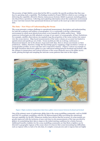
The ocean presents a unique challenge to operational measurement, description and understanding for both the academic and military oceanographer; it is a continually evolving 3-dimensional environment in which most physical processes occur beneath the visible surface layer. While numerous technologies provide adequate coverage of one aspect of oceanography, all have limitations. For example, satellite observations can regularly map the properties of the ocean surface but cannot view the ocean interior. Ship-based measurements of the water column are accurate but limited in spatial extent and quickly go out of date. Ocean models provide an evolving, continuous 3- dimensional dataset, but in the absence of ground-truth data, there is always uncertainty on their predictions. Gliders, therefore, bridge this knowledge gap by supplying a high resolution ‘curtain’ of oceanographic profiles, in near real-time and a responsive manner. (Figure 7) shows an example of the high-resolution data from a glider in a geo-referenced setting between Scotland and Iceland, with the changes in temperature and vertical structure of the ocean distinctly seen as the glider moves north, passing through and sampling the intricate ocean patterns that exist in this region.
Figure 7 High-resolution temperature data from a glider return transect between Scotland and Iceland
One of the primary users of underwater glider data is the ocean modelling community, such as SAMS and NOC for academic modelling, with the UK Meteorological Office providing the operational forecast capability for the RN. Numerous studies have shown that the accuracy of ocean models are greatly improved with the inclusion of near real-time in-situ measurements of the type provided by gliders, by assimilating their data to improve the initial starting conditions for a future forecast. Additional benefits of gliders for the ocean modelling community are that fleets of gliders can be directed to geographic regions of the ocean where it is known that ocean forecasting has difficulties, such as regions with a) a lack of in-situ data, b) complex ocean process and c) regions that are highly
9
