
Page 27 - Ranger Demo
P. 27
indicates the Hoengsan station and Gunnam Dam in South Korea. The yellow line shows the border boundary between North and South Korea (map data ©2018 Google Earth).
Monitoring River Basin Development of the Imjin River in North Korea
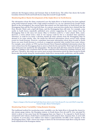
The information about the dams constructed over the Imjin River in North Korea has been updated using multi-temporal images with a high spatial resolution (15–30 cm) obtained from Google Earth. Based on the investigation, the current dams that existed over the Imjin River in North Korea are the Hwanggang Dam and the First April 5th Dam. In contrast, most previous studies have claimed that the First, Second, Third, and 4 April 5th Dams, and the Hwanggang Dam still exist. For example, some media in South Korea repeatedly published news articles suggesting the water release from the Hwanggang Dam in the 2015 wet season (May to October) could be a ‘water attack’ (Kim, 2016). However, a water release from a dam in wet seasons could be due to a standard dam operation. Therefore, it could be too hasty a decision should all water releases from the Hwanggang Dam be deemed to be water attacks. Also, the media has delivered information about several water release events for South Koreans. However, sometimes inaccurate information about dams located in North Korea can cause South Koreans to overlook or exaggerate potential risks resulted from water release. For example, news articles on YTN (24-hour Korean News Channel) published information about the water release from the Hwanggang Dam in 2016 in which the Second and the Third April 5th Dams that were destroyed were marked in the infographics. The Second April 5th Dam cannot be found in 2013 (Figure 2) leading to the conclusion that the dam could have been destroyed sometime between 2011 and 2013. Therefore, this study can convey more accurate information about the dams located in North Korea near the border along the transboundary Imjin River among media, politicians, and the public.
Figure 2 Images of the Second April 5th Dam from 2002 to 2017 (Lat 38.3214°N, Lon 126.8783°E, map data ©2019 Google, Maxar Technologies)
Monitoring Water Variability Using Remote Sensing
The traditional method for monitoring water variability over the Imjin River is through the closest in- situ stream gauge station, the Hoengsan station, in South Korea (Lat 38.1108°N, Lon 126.9606°E), which is about 47 km away from the Hwanggang Dam (see Figure 1). To respond to North Korea’s unexpected water release, South Korea constructed a multi-purpose dam, Gunnam Dam, in 2010 with a capacity of 0.076 km3 (70.6 million tons which is approximately one-fifth of the capacity of the Hwannggang Dam). Table 1 shows four stages of alerts for the downstream Imjin River using the water levels measured at the Hoengsan station.
25
