
Page 37 - Ranger Demo
P. 37
the coastal eminences to complete their observations. They produced an effective representation of a fringe of topography along the southern and western coasts which Hurd had especially emphasised. Here Smyth's concern was to have the 'various dangers distinctly pointed out'. He had a clear policy in drawing up the fair sheets. 'I have inserted no more soundings than I considered necessary'. Thus, in the coastal margin off Gergenti (Agrigento) (Fig. 6) representative soundings are shown, and the offshore banks are emphasised by leaving the adjacent deep-water areas blank. A collector sheet for the Sicilian Channel, which has been preserved in the UKHO archive, shows the density of sounding from which Smyth made the selection for his charts.
The author of this article has walked the north- west coast and can vouch for the depiction of it in Smyth's fair sheet (Fig. 7) and the associated descriptions and directions. Cap San Vito was the expected landfall on this coast. It was on these beaches that flotsam came ashore from the wreck of the British ship of the line Athenien on the dreaded Skerki Bank. The prominent coastal watchtowers and other features, many of which still feature on today's charts, are carefully illustrated for vessels coasting between Palermo and Trapani. The effective hill-shading employs the 'scale of shade', the darker, the steeper, which would have been taught to Smyth's companions at the Military College as part of the 'British National Standard'.20 When Cacciatore, Piazzi's successor as Astronomer Royal at Palermo, triangulated this area in 1829, he praised the accuracy of Smyth's survey.21
Smyth carried his work from the depths to the very highest point on the island. He took great care in observing for the position and height of Mount Etna and has left a vivid description of the evolutions, during which his companion, Henryson, was incapacitated in a 'violent ejection of dense and sulphurous smoke'. He left an equally atmospheric account of his experiences ashore and afloat whilst patrolling and surveying around Stromboli in the Aeolian Islands, where his anchorage was exposed to 'incessant showers of red-hot stones [...] most of which fell very near us, while some of them exploded in the air with a
whizzing sound, like the fragments of bomb-shells after bursting'.22 In both locations, he made a careful collection of geological specimens. He was aghast when these, together with collections of seashells and of plants, were seized and sold by the Excise officers after he sent them back to England.23
It was indeed the age of observation right across the scientific spectrum, and Smyth was encouraged by the Lords of the Admiralty to exercise all his interests as a polymath. He was a numismatist and
20 Y. Hodson, Ordnance Surveyors’ Drawings, 13; Close, op. cit., 77-79; Clark and Jones, British Military Map- making in the Peninsular War, 6
21 Smyth, Memoir of Sicily, 245; The Mediterranean, 361
22 Smyth, Memoir of Sicily, 150 and 252-3
23 TNA ADM 1/2546, Cap S 95, letter dated 17 Apr. 1818
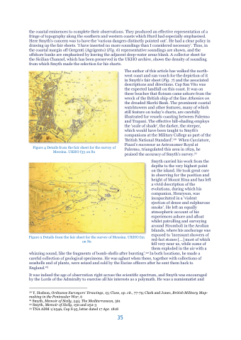
Figure 4 Details from the fair sheet for the survey of Messina. UKHO f35 on Su
Figure 5 Details from the fair sheet for the survey of Messina. UKHO f35 on Su
35
