
Page 36 - Ranger Demo
P. 36
'principal functionaries'. He was allocated 'one of their finest gunboats' together with sturdy sounding boat. The normal work of the Sicilian flotilla vessels was in the service of the health office and the sailors, whom Smyth described as 'cheerful, hardy and daring', would almost certainly have welcomed their employment on the survey.13
Though earnest, Smyth is said to have had a robust sense of humour.14 He had no trouble in attracting helpers. He was joined in the course of the survey by his half-brother, the artist Augustus Earle, who may have assisted in the fairing up of views, and especially in their preparation for publication.15As the garrison of Sicily dispersed, Smyth, a persuasive enthusiast, enlisted two other officers who were awaiting orders: Captain John Henryson of the Royal Engineers, and Lieutenant Edward Thompson of the Royal Staff Corps. Henryson had gained his commission as a first lieutenant as the bearing of the Corps was increased in July 1806 to meet the increasing demand for front-line combat engineering support. He was promoted to second-captain on 1 May 1811. He may have been a brother of Captain William Henryson Royal Navy, for both men are recorded as resident in Stranraer. He was certainly accustomed to working with the Royal Navy having been sent from Sicily in 1812 to supervise the construction of fortifications for the chosen naval base at Porto San Giorgio, Lissa.16 Edward Thompson had obtained a commission as an ensign in the Royal Staff Corps in November 1807 and had been promoted lieutenant in March 1810.17 Smyth records that:
These gentlemen, as my guests, [...] accompanied me
round the island [...] and [...] gave me the only personal assistance I received, aiding me greatly in sketching the topography and fortifications during the time occupied by my nautical and astronomical operations, and assisting in the reduction of the various observations.
Smyth summarised his survey process in the introduction to his published description of Sicily.18 In his fair sheets, which had been 'constructed trigonometrically', 'the true meridian is invariably used; whilst in the descriptive part, the magnetic variation is allowed for in the direction of winds and tides, as well as on the bearings of places'. He concluded: 'I have endeavoured to express the hydrography, fortifications and topography, with as much detail as the nature of a service, limited in time, would admit'.
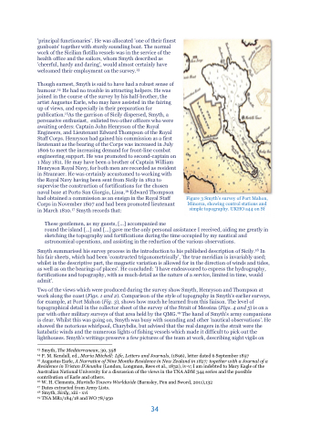
Two of the views which were produced during the survey show Smyth, Henryson and Thompson at work along the coast (Figs. 1 and 2). Comparison of the style of topography in Smyth's earlier surveys, for example, at Port Mahon (Fig. 3), shows how much he learned from this liaison. The level of topographical detail in the collector sheet of the survey of the Strait of Messina (Figs. 4 and 5) is on a par with other military surveys of that area held by the QMG.19 The hand of Smyth's army companions is clear. Whilst this was going on, Smyth was busy with sounding and other 'nautical observations'. He showed the notorious whirlpool, Charybdis, but advised that the real dangers in the strait were the katabatic winds and the numerous lights of fishing vessels which made it difficult to pick out the lighthouses. Smyth's writings preserve a few pictures of the team at work, describing night vigils on
13 Smyth, The Mediterranean, 30, 358
14 P. M. Kendall, ed., Maria Mitchell: Life, Letters and Journals, (1896), letter dated 6 September 1857
15 Augustus Earle, A Narrative of Nine Months Residence in New Zealand in 1827; together with a Journal of a Residence in Tristan D’Acunha (London, Longman, Rees et al., 1832), iv-v; I am indebted to Mary Eagle of the Australian National University for a discussion of the views in the TNA ADM 344 series and the possible contribution of Earle and others.
16 W. H. Clements, Martello Towers Worldwide (Barnsley, Pen and Sword, 2011),132
17 Dates extracted from Army Lists.
18 Smyth, Sicily, xiii - xvi
19 TNA MR1/184/18 and WO 78/950
34
Figure 3 Smyth’s survey of Port Mahon, Minorca, showing control stations and simple topography. UKHO a44 on Sf
