
Page 103 - ShareSpace's Mars Map Teacher's Guide - Sept 2016
P. 103
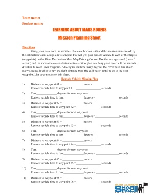
Team name:
Student name:

               LEARNING ABOUT MARS ROVERS
                  Mission Planning Sheet

Directions:

         Using your data from the remote vehicle calibration tests and the measurements made by
the calibration team, design a mission plan that will get your remote vehicle to each of the targets
(waypoints) on the Giant Destination Mars Map Driving Course. Use the average speed (meter/
second) and the measured course distances (meters) to plan how long your rover will run in each
direction to reach each waypoint. Also figure out how many degrees the rover must turn (how
many seconds it takes to turn the right distance from the calibration tests) to go to the next
waypoint. List your moves on this sheet.

                                        Remote Vehicle Mission Plan

1) Distance to waypoint #1 =                   meters
         Remote vehicle time to waypoint #1 =
                                                          seconds

2) Turn        degrees for next waypoint

Remote vehicle time to turn                    degrees =           seconds

3) Distance to waypoint #2 =                   meters
         Remote vehicle time to waypoint #2 =
                                                          seconds

4) Turn        degrees for next waypoint

Remote vehicle time to tum                     degrees =           seconds

5) Distance to waypoint #3 =                   meters
         Remote vehicle time to waypoint #3 =
                                                          seconds

6) Turn        degrees for next waypoint

Remote vehicle time to turn                    degrees =           seconds

7) Distance to waypoint #4 =                   meters
         Remote vehicle time to waypoint #4 =
                                                          seconds

8) Turn        degrees for next waypoint

Remote vehicle time to turn                    degrees =           seconds

9) Distance to waypoint #5 =                   meters
         Remote vehicle time to waypoint #5 =
                                                          seconds

10) Turn       degrees for next waypoint

Remote vehicle time to turn                    degrees =           seconds

11) Distance to waypoint #6 =                  meters
         Remote vehicle time to waypoint #6 =
                                                          seconds