
Page 11 - spring 2019
P. 11
Friends oF red rock canyon 11
By Chad Kooistra, Jerry Keir and
Will Rempel
Objective 2: Understand Visitor and Stakeholder Perceptions of Capacity Issues at RRC Objective 3: Characterize Vehicle Travel and
Parking Issues Throughout the Loop
We conducted open-ended and fixed-choice surveys with visitors, volunteers, permittees and
other stakeholders to understand their experiences, perceptions of capacity-related issues and We collected a substantial amount of data to help
their attitudes about different management strategies. describe and quantify vehicle travel and parking
characteristics around the Loop for use in future plan-
• Overall, typical visitors are highly satis- a wide range of topics and more op- ning and monitoring efforts.
fied with their recreation experiences. portunities to engage directly with BLM
Improving restroom and other facility and Southern Nevada Conservancy staff. • The weeks with the highest visitation at
cleanliness, providing more informa- • Permittees generally perceive increased RRC are typically late March into early April,
tion on protecting cultural and natural visitation as a positive situation. They Thanksgiving week, other holidays and fee
resources, and enhancing trail ADA are most concerned about congestion free days.
accessibility options would lead to even and wait times at the entrance station • Visitation at the Calico Basin Road noticeably
higher satisfaction levels. and safety for their customers using increases when the Loop closes.
• Long-time users and members of smaller or human-powered vehicles • The Calico II, Lower White Rock and Ice Box
stakeholder groups are more aware of along the Loop. Canyon parking areas were near or above
visitation and capacity-related impacts. • There appears to be general support 100% capacity, and at times, were recorded at
These include increased graffiti, litter, for enhancing communication and 300% capacity.
congestion at the entrance station and outreach about capacity decisions, im- • The Loop segments between Calico II and
parking areas along the Loop, and the proving signage along trails, providing High Point Overlook and Willow Spring to Red
sometimes confusing multi-use nature more signage and demarcation along Rock Wash Overlook were most likely to have
of the Loop. the Loop and at the entrance station, cars parked along the road. Heaviest conges-
• Many frequent or regular visitors adjust providing Wi-Fi and cell service in some tion along the Loop is between Sandstone
their visits to avoid congestion. areas of RRC, exploring potential shuttle Quarry and Lower White Rock.
• Volunteers would like more informa- or parking reservation options for peak • The average time to get through the entrance
tional materials to give to visitors about use and increasing official presence. station was five minutes, though it was up
to six times longer on busy days. Six out of
53 observation sessions recorded vehicles
backed up on State Route 159.
Objective 4: Provide Public and Agency Benefits
We engaged RRC officials, visitors, volunteers
and other stakeholders in various ways. A total
of 640 hours contributed to our project. This in-
cluded documenting their perspectives, provid- All images provided by GBI
ing outreach opportunities about our project and
capacity issues at RRC, and developing protocols
and training volunteers to facilitate reliable fu-
ture monitoring efforts.
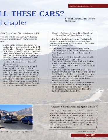
Background image: The Loop as seen from Sandstone Quarry. Above: Waiting at the entrance. (Continued on page 12)
Spring 2019