
Page 36 - eatg
P. 36
the winter. The community of Dease Lake is a popular
stop over destination along the Stewart-Cassiar Hwy.
This region has a history rich in adventure dating
back to before the Cassiar Gold Rush. While gold
brought the early large influx of prospectors, today
other minerals add support to the economy. Jade is
found in commercial quantities. Visitor Information
Website: www.stewartcassiarhighway.com.
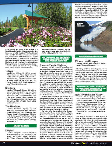
Salmon Glacier
photo by:
VC TRAVEL GUIDE
Granisle Memorial Park
of the Bulkley and Morice Rivers, Houston is a Information Centre, for village tours, raft trips,
beautiful vacation location. Houston’s excellent river canoe rentals, arts and crafts, phone: (250) 842-
fishing has earned it the title of “Steelhead Capital 7057 or toll free: (877) 842-5911.
of the World.” The Morice River holds rainbow
trout, cutthroat trout and Dolly Varden and it offers STEWART-CASSIAR HWY 37 NORTH
outstanding fishing for Steelhead trout, chinook and JCT. YELLOWHEAD HWY 16 & STEWART-
CASSIAR HWY 37 NORTH TO WATSON
coho salmon in season. The area is known for superb LAKE, YUKON ON ALASKA HWY Kitwancool/Gitanyow
lake fishing as well. Steelhead Park is located along
Highway 16 next to the Visitor Information Centre. Location: Stewart-Cassiar Highway 37, 9 miles
Houston offers full travel facilities, including Stewart-Cassiar Highway north of Kitwanga/Gitwangak.
hotels, motels, campsites, and retail shopping. Stretching over 724 kilometers (450 miles) from The village of Kitwancool (Gitanyow) is the site
Telkwa the Skeena River and Yellowhead Hwy 16 in the south of many ancient, impressive totem poles. The famous
to the Alaska Hwy near Watson Lake, Yukon in the
Location: On Highway 16, halfway between north, this region offers you some of the most intense Canadian painter Emily Carr captured the striking
Prince George and Prince Rupert; 10 miles wilderness lands on the North American continent. majesty of many of these poles after a visit to the
southeast of Smithers, 30 miles north of Houston. Massive glaciers, raging rivers, crystal clear lakes, area in 1928. “Hole-in-the-lce” is the oldest standing
Population: 1416. Visitor Information: Village and streams all vie with the pristine and untouched totem pole in the world. Carving sheds, a graveyard,
of Telkwa, PO Box 220, Telkwa, BC, V0J 2X0; lands that mark this region. The Stewart-Cassiar and a community smoke-house also occupy this site,
Phone: (250) 846-5212; Email: info@telkwa. Hwy 37 connects the communities in this region. It a living museum of totem carving.
com; Website: www.telkwa.com is considered an excellent alternative route to reach
the Yukon and Alaska. This mostly paved highway CRANBERRY JCT. ON HWY 37 & NISGA’A
Smithers (less than 15% graveled) is always maintained in HWY/NASS FOREST SERVICE ROAD TO YEL-
Location: Yellowhead Highway 16, halfway top condition for all types of holiday or commercial LOWHEAD HWY 16 AT TERRACE
between Prince George (371 km) and Prince vehicles and travelers. Hwy 37 is part of a wonderful
Rupert (356 km) in the Bulkley Valley. circle tour route that encompasses Hwy 16, Hwy 97 New Aiyansh/Nass Valley
Population: 5500. Visitor Information: 1411 and the Alaska Hwy.
Court Street; Smithers District Chamber, PO Another intriguing part of your journey in the Location: On the Nisga’a Highway. Turn
Box 2379, Smithers, BC V0J 2N0; Phone: (800) Stewart-Cassiar region is a side trip on Hwy 37A west off Stewart-Cassiar Hwy 37 at Cranberry
542-6673 or (250) 847-5072; Email: info@ into Stewart, BC and Hyder, Alaska. Nestled around Junction kilometer marker 76, for approximately
tourismsmithers.com. the edges of a long fjord, these communities are co- 37 miles; an alternate route begins 2 miles west
existent at the toe of the Alaska Panhandle, separated of the Terrace Information Center on Hwy 16,
The Hazeltons only by an international boundary. It is along this north along the Kalum Lake Road for 48 miles.
route that you will be able to view some of the most
Location: Yellowhead Highway 16; 278 dramatic and colorful glaciers on the continent. Tourist Information: New Aiyansh Village
Government, P.O. Box 233 New Aiyansh, BC
miles from Prince George. Area Population: The native tribes that have long called this awe-
Approximately 6,500. Visitor Information: New inspiring region home are the Gitxsan, Nisga’a, V0J 1A0, phone: (250) 633-3100, email: navq@
osg.net.
Hazelton Visitor Information Center, Highway Tahltan, and Kaska peoples. Their communities
16 & 62, just west of New Hazelton. PO Box offer you a glimpse into the rich cultural heritages The Nisga’a community of New Aiyansh is
340; 4070 9th Ave. New Hazelton, BC VOJ that have formed their way of life. It is well worth a located 37 miles down this southwesterly running
2J0; Phone: (250) 842-6071; Email: tourism@ visit to each one to learn about and experience their
newhazelton.ca. perspectives for yourself. There are a wide variety of paved road, which follows the Nass River through a
valley of lava beds, created in Canada’s most recent
campgrounds and facilities along the Stewart-Cassiar volcanic eruption. In 1750, lava erupted from a
JCT. HWY 16 & HWY 62 with services available for the traveler. (Mileage is 328 foot high cinder cone and flowed into the Nass
from the Alaska Highway.) At mile 74.8 is the Jade Valley, pushing the river aside and destroying native
Kispiox City Store, where you can purchase raw jade, cut jade villages. The Nisga’a Memorial Lava Bed Provincial
and see the mine itself. At mile 190, stay at the Bear
Park surrounds and protects this unique site, where
Location: On Hwy 62, 9 miles north of Hazelton Paw Ranch Wilderness Resort where they offer 16 visitors may explore two large lava tubes and hike
in the Bulkley Valley at the confluence of the suites in the Alpine Hotel or a variety of themed guest to the petroglyphs carved on cliffs above the unusual
Skeena and Kispiox Rivers. Population: cabins. Mile 292 is Bell 2 Lodge, where you can hike, red sand beaches of Lava Lake. Lodging is available
651. Visitor Information: Kispiox Cultural/ bike, hunt, and fish during the summer and heliski in within the community.
58