
Page 58 - Smart City Brochure
P. 58
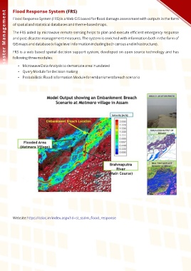
Flood Response System (FRS)
Disaster Management
Flood Response System (FRS) is a Web GIS based for flood damage assessment with outputs in the form
of spatial and statistical databases and theme-based maps.
The FRS aided by microwave remote sensing helps to plan and execute efficient emergency response
and post disaster management measures. The system is enriched with information both in the form of
GIS maps and database (village level information including both census and infrastructure).
FRS is a web based spatial decision support system, developed on open source technology and has
following three modules:
Microwave Data Analysis to demarcate area inundated
Query Module for decision making
Probabilistic Flood Information Module for embankment breach scenario
Website:https://cdac.in/index.aspx?id=st_ssdm_flood_response