Page 147 - UK ATM ANS Regulations (Consolidated) 201121
P. 147
Part MET - ANNEX V - Specific Requirements for the Providers of Meteorological
                                                        Services


             MET.TR.250(c) AMC1      SIGMET
                                      SEQUENCE NUMBER
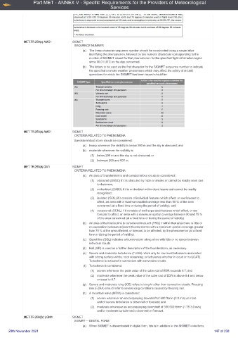
                                          (a)  The three-character sequence number should be constructed using a single letter
                                              identifying the phenomenon, followed by two numeric characters corresponding to the
                                              number of SIGMET issued for that phenomenon for the specified flight information region
                                              since 00.01 UTC on the day concerned.
                                          (b)  The letters to be used as the first character for the SIGMET sequence number to indicate
                                              the specified en-route weather phenomena which may affect the safety of aircraft
                                              operations for which the SIGMET has been issued should be:


             MET.TR.250(d) AMC1      SIGMET
                                      CRITERIA RELATED TO PHENOMENA
                                      Sandstorm/dust storm should be considered:
                                          (a)  heavy whenever the visibility is below 200 m and the sky is obscured; and
                                          (b)  moderate whenever the visibility is:
                                              (1)  below 200 m and the sky is not obscured; or
                                              (2)  between 200 and 600 m.
             MET.TR.250(d) GM1       SIGMET
                                      CRITERIA RELATED TO PHENOMENA
                                          (a)  An area of thunderstorms and cumulonimbus clouds is considered:
                                              (1)  obscured (OBSC) if it is obscured by haze or smoke or cannot be readily seen due
                                                  to darkness;
                                              (2)  embedded (EMBD) if it is embedded within cloud layers and cannot be readily
                                                  recognised;
                                              (3)  isolated (ISOL) if it consists of individual features which affect, or are forecast to
                                                  affect, an area with a maximum spatial coverage less than 50 % of the area
                                                  concerned (at a fixed time or during the period of validity); and
                                              (4)  occasional (OCNL) if it consists of well-separated features which affect, or are
                                                  forecast to affect, an area with a maximum spatial coverage between 50 and 75 %
                                                  of the area concerned (at a fixed time or during the period of validity).
                                          (b)  An area of thunderstorms is considered frequent (FRQ) if within that area there is little or
                                              no separation between adjacent thunderstorms with a maximum spatial coverage greater
                                              than 75 % of the area affected, or forecast to be affected, by the phenomenon (at a fixed
                                              time or during the period of validity).
                                          (c)  Squall line (SQL) indicates a thunderstorm along a line with little or no space between
                                              individual clouds.
                                          (d)  Hail (GR) is used as a further description of the thunderstorm, as necessary.
                                          (e)  Severe and moderate turbulence (TURB) refers only to: low-level turbulence associated
                                              with strong surface winds; rotor streaming; or turbulence whether in cloud or not (CAT).
                                              Turbulence is not used in connection with convective clouds.
                                           (f) Turbulence is considered:
                                              (1)  severe whenever the peak value of the cube root of EDR exceeds 0.7; and
                                              (2)  moderate whenever the peak value of the cube root of EDR is above 0.4 and below
                                                  or equal to 0.7.
                                          (g)  Severe and moderate icing (ICE) refers to icing in other than convective clouds. Freezing
                                              rain (FZRA) should refer to severe icing conditions caused by freezing rain.
                                          (h)  A mountain wave (MTW) is considered:
                                              (1)  severe whenever an accompanying downdraft of 600 ft/min (3.0 m/s) or more
                                                  and/or severe turbulence is observed or forecast; and
                                              (2)  moderate whenever an accompanying downdraft of 350 600 ft/min (1.75 3.0 m/s)
                                                  and/or moderate turbulence is observed or forecast.
             MET.TR.250(f)(1) GM1    SIGMET
                                      SIGMET — DIGITAL FORM
                                          (a)  When SIGMET is disseminated in digital form, this is in addition to the SIGMET code form.
     20th November 2021                                                                                     147 of 238

