
Page 35 - ARQUEOLOGIA IBEROAMERICANA
P. 35
ISSN 1989–4104 ARQUEOLOGIA IBEROAMERICANA 4 (2009) 35
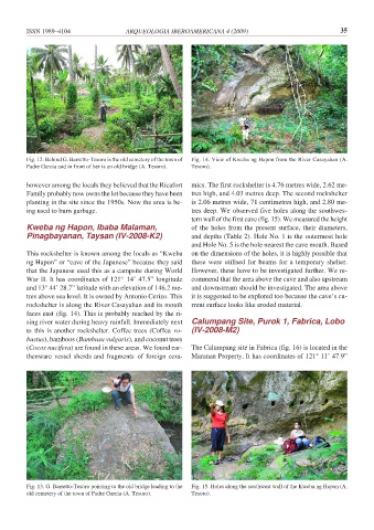
Fig. 12. Behind G. Barretto-Tesoro is the old cemetery of the town of Fig. 14. View of Kweba ng Hapon from the River Casayahan (A.
Padre Garcia and in front of her is an old bridge (A. Tesoro). Tesoro).
however among the locals they believed that the Ricafort mics. The first rockshelter is 4.76 metres wide, 2.62 me-
Family probably now owns the lot because they have been tres high, and 4.03 metres deep. The second rockshelter
planting in the site since the 1950s. Now the area is be- is 2.06 metres wide, 71 centimetres high, and 2.80 me-
ing used to burn garbage. tres deep. We observed five holes along the southwes-
tern wall of the first cave (fig. 15). We measured the height
Kweba ng Hapon, Ibaba Malaman, of the holes from the present surface, their diameters,
Pinagbayanan, Taysan (IV-2008-K2) and depths (Table 2). Hole No. 1 is the outermost hole
and Hole No. 5 is the hole nearest the cave mouth. Based
This rockshelter is known among the locals as “Kweba on the dimensions of the holes, it is highly possible that
ng Hapon” or “cave of the Japanese” because they said these were utilised for beams for a temporary shelter.
that the Japanese used this as a campsite during World However, these have to be investigated further. We re-
War II. It has coordinates of 121° 14’ 47.5” longitude commend that the area above the cave and also upstream
and 13° 44’ 28.7” latitude with an elevation of 146.2 me- and downstream should be investigated. The area above
tres above sea level. It is owned by Antonio Cerizo. This it is suggested to be explored too because the cave’s cu-
rockshelter is along the River Casayahan and its mouth rrent surface looks like eroded material.
faces east (fig. 14). This is probably reached by the ri-
sing river water during heavy rainfall. Immediately next Calumpang Site, Purok 1, Fabrica, Lobo
to this is another rockshelter. Coffee trees (Coffea ro- (IV-2008-M2)
bustus), bamboos (Bambusa vulgaris), and coconut trees
(Cocos nucifera) are found in these areas. We found ear- The Calumpang site in Fabrica (fig. 16) is located in the
thenware vessel sherds and fragments of foreign cera- Maranan Property. It has coordinates of 121° 11’ 47.9”
Fig. 13. G. Barretto-Tesoro pointing to the old bridge leading to the Fig. 15. Holes along the southwest wall of the Kweba ng Hapon (A.
old cemetery of the town of Padre Garcia (A. Tesoro). Tesoro).