
Page 139 - A Walk to Caesarea / Joseph Patrich
P. 139
Late Arab A Walk to Caesarea: A Historical-Archaeological Perspective 125
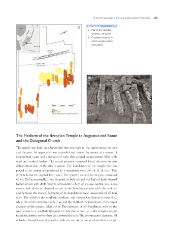
drain a Fig. 143a–b
N a. Plan of the Crusader
Eastern edge
of Arab road cemetery compound
b. Crusader cist graves in
which wooden coffins
were placed
b
0 5m
Burials
Cyst burials
Disarticulated bones and possible coffin burials
The Platform of the Herodian Temple to Augustus and Rome
and the Octagonal Church
The temple was built on a kurkar hill that rose high in the center above the city
and the port. Its upper area was expanded and leveled by means of a system of
longitudinal vaults and a network of walls that created compartments filled with
sand and crushed kurkar. The sacred precinct (temenos) faced the port; its axis
differed from that of the streets system. The foundations of the temple that was
placed at its center are preserved to a maximum elevation of 11 m a.s.l. This
level is below its original floor level. The temple, rectangular in plan, measured
46.4 x 28.6 m externally. It was founded on bedrock and was built of finely dressed
kurkar ashlars with draft margins surrounding a high or shallow central boss. Gray
mortar with flecks of charcoal served as the bonding element with the bedrock
and between the stones. Segments of its foundations were uncovered on all four
sides. The width of the northern, southern, and eastern foundations is some 8 m,
while that of the western is only 3 m, and the width of the foundation of the inner
chamber of the temple (cella) is 5 m. The existence of two foundation walls on the
west attests to a vestibule (pronaos) on this side as well as to the temple’s façade
facing the harbor rather than east, toward the city. The architectural elements, all
of kurkar, though found dispersed, enable the reconstruction of a Corinthian temple