
Page 137 - A Walk to Caesarea / Joseph Patrich
P. 137
A Walk to Caesarea: A Historical-Archaeological Perspective 123
The destroyed walls of Louis IX delimit a more or less rectangular area whose
dimensions from north to south are c. 450 m and from west to east c. 240 m. On
the west was a sea wall of which there are meager remains and a fortress that
stood south of the harbor. On the south and east Louis IX’s construction was set
upon older walls, from the Abbasid and Fatimid periods. The excavations in the
northeastern corner of the wall show that the wall of the Muslim city continued
further north, beyond the Crusader line.
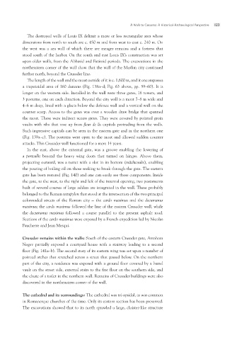
The length of the wall and the moat outside of it is c. 1,600 m, and it encompasses
a trapezoidal area of 160 dunams (Fig. 138a–d; Fig. 63 above, pp. 59–60). It is
longer on the western side. Installed in the wall were three gates, 16 towers, and
3 posterns, one on each direction. Beyond the city wall is a moat 7–8 m wide and
4–6 m deep, lined with a glacis below the defence wall and a vertical wall on the
counter scarp. Access to the gates was over a wooden draw bridge that spanned
the moat. These were indirect access gates. They were covered by pointed groin
vaults with ribs that rose up from fleur de lis capitals protruding from the walls.
Such impressive capitals can be seen in the eastern gate and in the northern one
(Fig. 139a–c). The posterns were open to the moat and allowed sudden counter
attacks. This Crusader wall functioned for a mere 14 years.
In the east, above the external gate, was a groove enabling the lowering of
a portcullis beyond the heavy wing doors that turned on hinges. Above them,
projecting outward, was a turret with a slot in its bottom (mâchicoulis), enabling
the pouring of boiling oil on those seeking to break through the gate. The eastern
gate has been restored (Fig. 140) and one can easily see these components. Inside
the gate, to the west, to the right and left of the internal opening, two postaments
built of several courses of large ashlars are integrated in the wall. These probably
belonged to the Roman tetrapylon that stood at the intersection of the two principal
colonnaded streets of the Roman city – the cardo maximus and the decumanus
maximus; the cardo maximus followed the line of the eastern Crusader wall, while
the decumanus maximus followed a course parallel to the present asphalt road.
Sections of the cardo maximus were exposed by a French expedition led by Nicolas
Faucherre and Jean Mesqui.
Crusader remains within the walls: South of the eastern Crusader gate, Avraham
Negev partially exposed a courtyard house with a stairway leading to a second
floor (Fig. 141a–b). The second story of its eastern wing was set upon a number of
pointed arches that stretched across a street that passed below. On the northern
part of the city, a residence was exposed with a ground floor covered by a barrel
vault on the street side, external stairs to the first floor on the southern side, and
the chute of a toilet in the northern wall. Remains of Crusader buildings were also
discovered in the northeastern corner of the wall.
The cathedral and its surroundings: The cathedral was tri-apsidal, as was common
in Romanesque churches of the time. Only its eastern section has been preserved.
The excavations showed that to its north sprawled a large, cloister-like structure