
Page 147 - A Walk to Caesarea / Joseph Patrich
P. 147
A Walk to Caesarea: A Historical-Archaeological Perspective 133
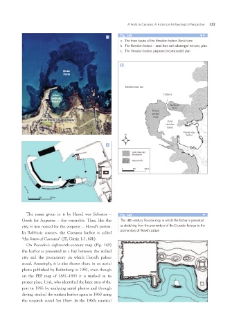
a Fig. 149
a. The three basins of the Herodian harbor. Aerial view
b. The Herodian harbor – sand bars and submerged remains, plan
c. The Herodian harbor, proposed reconstructed plan
b
Outer Mediterranean Sea
Basin
Inter- Entrance
mediate
Bassin Ruined Northern
Inner Basin (clogged today) western mole
mole Outer
Herodian
harbor
Present-day
N harbor
c
Sunk moles and
breakwaters
Natural reefs
0 100 200 m
N
0 100 200 m
The name given to it by Herod was Sebastos – Fig. 149
Greek for Augustus – the venerable. Thus, like the
city, it was named for the emperor – Herod’s patron. The 18th-century Pococke map in which the harbor is presented
In Rabbinic sources, the Caesarea harbor is called as stretching from the promontory of the Crusader fortress to the
“the limen of Caesarea” (JT, Gittin 1:3, 60b). promontory of Herod’s palace
On Pococke’s eighteenth-century map (Fig. 149)
the harbor is presented in a bay between the walled
city and the promontory on which Herod’s palace
stood. Amazingly, it is also shown there in an aerial
photo published by Reifenberg in 1951, even though
on the PEF map of 1881–1883 it is marked in its
proper place. Link, who identified the large area of the
port in 1956 by analyzing aerial photos and through
diving, studied the sunken harbor again in 1960 using
the research vessel Sea Diver. In the 1960s nautical