
Page 148 - A Walk to Caesarea / Joseph Patrich
P. 148
134 Archaeological Review surveys continued, and from 1975 on, under-water excavations were carried out
by a joint expedition of researchers from Canada, the US and Israel, and afterward
Fig. 150 by an expedition of the University of Haifa led by Avner Raban, who was also
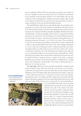
The mole of the inner basin co-director of the Joint Expedition. Underwater research continues today. Coastal
and a mooring stone with an drift of underwater sands by the sea currents reveals a growing number of remains of
intrusive hole sunken vessels that in the past were buried beneath the sand.
The small Hellenistic harbor that preceded the Herodian one was built in-land,
apparently in an estuary of an ancient stream, from prehistoric times (Fig. 9 above,
p. 6). The archeological finds uncovered in the underwater survey and excavations
match the above description by Flavius Josephus remarkably. The Herodian harbor,
with all its parts – the inner, intermediate, and outer basins – penetrated some 400 m
into the sea. Its total area was over 200 dunams (c. 50 acres); in Raban’s estimation
the total length of its quays – the places for anchorage and secondary places for
anchoring in Josephus’ description – was 1,200 m or even more. This was sufficient
to allow for the anchoring and unloading of many dozens of ships simultaneously
as well as to provide them shelter from storms in the winter. Josephus described it
as a port of calm waters, being protected by a breakwater and wide quays. Since
the dangerous direction of the wind and waves is from the southwest, the entrance
to the harbor was placed in the north. The harbor was bordered on the south and
west by a mole whose outline was a bit curved and whose total length was c. 600 m
(including the peninsula and the harbor fortress enclosing the intermediate basin);
its width was 40–60 m. In the sea beyond it, mainly on the south, a submerged
breakwater was uncovered. To the north the harbor was delineated by a straight
mole c. 200 m long and c. 40–60 m wide. These moles are submerged today to a
depth of c. 6–7 m below sea level.
The inner basin, which was rock-cut in land, included the contained, closed
harbor of Straton’s Tower, which was bordered on the west by a sea wall with a
round tower at its end, located c. 20 m from today’s shore line (its remains are found
beneath sea level). The length of the original inner pool, from north to south, was
c. 250 m. Metal strips interwoven in the present pavement south of the Crusader
wall mark the course of its southern end. The northern edge was located within the
bounds of the present parking lot near the Crusaders Restaurant. Between the round
tower and today’s “Harbor Fortress” was an opening 20–30 m wide, which linked it
to the intermediate basin. Parts of the moles of the
inner basin were uncovered in the east, north, and
southeast. The walls of the eastern, inner mole,
were not rock cut, but rather a casting of marine
concrete up to 10 m thick that contained volcanic
ash from Italy (pozzolana). On top of the cast wall
was set a mole of 2–3 courses of lengthened ashlar
slabs laid as headers, so that its top rose some 1.5
m above sea level. At a distance of c. 6 m from the
edges of the mole a plastered flushing channel was
installed, that allowed sea water to penetrate from