
Page 15 - A Walk to Caesarea / Joseph Patrich
P. 15
Historical Review
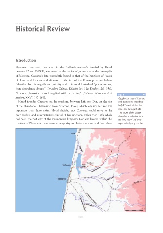
Introduction Fig. 1
Caesarea (קסרי, קיסרי, קסרין, קיסריןin the Rabbinic sources), founded by Herod Geophysical map of Caesarea
between 22 and 10 BCE, was known as the capital of Judaea and as the metropolis and its environs, including
of Palestine. Caesarea’s fate was tightly bound to that of the Kingdom of Judaea Nah. al Tanninim Lake, the
of Herod and his sons and afterward to the fate of the Roman province Judaea- roads and the aqueducts.
Palaestina. In this magnificent port city and in its rural hinterland “prices are low; The course of the Upper
there abundance obtains” (Jerusalem Talmud, Kil’ayim 9:4, 32c; Ketubot 12:3, 35b). Aqueduct is indicated by a
“It was a pleasant city well supplied with everything” (Expositio totius mundi et red line; that of the lower
gentium, XXVI, 160–161). aqueduct – by a green line
Herod founded Caesarea on the seashore, between Jaffa and Dor, on the site
of the abandoned Hellenistic town Straton’s Tower, which was smaller and less
important than those cities. Herod decided that Caesarea would serve as the
main harbor and administrative capital of his kingdom, rather than Jaffa which
had been the port city of the Hasmonean kingdom; Dor was located within the
confines of Phoenicia. Its economic prosperity and lofty status derived from these
.
.
.
. 0 5 km
1