
Page 16 - A Walk to Caesarea / Joseph Patrich
P. 16
2 Historical Review
decisions. The hinterland of Caesarea included
the southern edge of the Carmel, the northern
Sharon plain, and the northern hills of Samaria
(Figs. 1, 4). The city itself covered an area of sand
dunes and kurkar (calcareous sandstone) ridges.
To its east spread the fruitful Sharon, which from
earlier periods was known as a land of wheat and
good pasture. In the fourth century CE, the city
was distinguished for exporting purple dye, and
celebrated for its productivity in corn, wine and
oil (Fig. 2), in which all was abundant (Fig. 3). In
addition to commerce through sea channels, five
other trade routes linked it with the cities within
the country (Fig. 4).
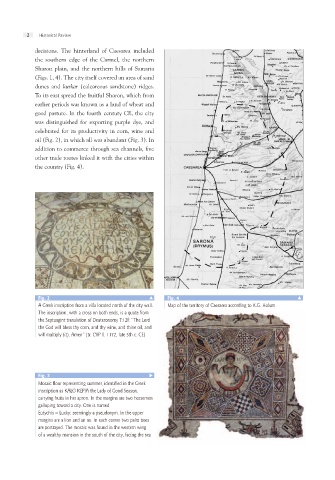
Fig. 2 1 איור Fig. 4 1 איור
Map of the territory of Caesarea according to K.G. Holum
A Greek inscription from a villa located north of the city wall.
The inscription, with a cross on both ends, is a quote from
the Septuagint translation of Deuteronomy 7:12f: “The Lord
the God will bless thy corn, and thy wine, and thine oil, and
will multiply (it). Amen” (tr. CIIP II. 1172, late 5th c. CE)
Fig. 3
Mosaic floor representing summer, identified in the Greek
inscription as KALO KEPIA the Lady of Good Season,
carrying fruits in her apron. In the margins are two horsemen
galloping toward a city. One is named
Eutychis – Lucky; seemingly a pseudonym. In the upper
margins are a lion and an ox. In each corner two palm trees
are portrayed. The mosaic was found in the western wing
of a wealthy mansion in the south of the city, facing the sea