
Page 5 - Langenburg Community Profile 2020-2021
P. 5
Langenburg
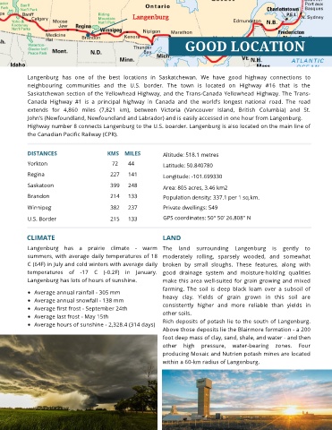
GOOD LOCATION
Langenburg has one of the best locations in Saskatchewan. We have good highway connections to
neighbouring communities and the U.S. border. The town is located on Highway #16 that is the
Saskatchewan section of the Yellowhead Highway, and the Trans-Canada Yellowhead Highway. The Trans-
Canada Highway #1 is a principal highway in Canada and the world’s longest national road. The road
extends for 4,860 miles (7,821 km), between Victoria (Vancouver Island, British Columbia) and St.
John’s (Newfoundland, Newfoundland and Labrador) and is easily accessed in one hour from Langenburg.
Highway number 8 connects Langenburg to the U.S. boarder. Langenburg is also located on the main line of
the Canadian Pacific Railway (CPR).
DISTANCES KMS MILES Altitude: 518.1 metres
Yorkton 72 44 Latitude: 50.840780
Regina 227 141 Longitude: -101.699330
Saskatoon 399 248 Area: 805 acres, 3.46 km2
Brandon 214 133 Population density: 337.1 per 1 sq.km.
Winnipeg 382 237 Private dwellings: 549
U.S. Border 215 133 GPS coordinates: 50° 50' 26.808'' N
CLIMATE LAND
Langenburg has a prairie climate - warm The land surrounding Langenburg is gently to
summers, with average daily temperatures of 18 moderately rolling, sparsely wooded, and somewhat
C (64F) in July and cold winters with average daily broken by small sloughs. These features, along with
temperatures of -17 C (-0.2F) in January. good drainage system and moisture-holding qualities
Langenburg has lots of hours of sunshine. make this area well-suited for grain growing and mixed
farming. The soil is deep black loam over a subsoil of
Average annual rainfall - 305 mm
Average annual snowfall - 138 mm heavy clay. Yields of grain grown in this soil are
Average first frost - September 24th consistently higher and more reliable than yields in
Average last frost - May 15th other soils.
Average hours of sunshine - 2,328.4 (314 days) Rich deposits of potash lie to the south of Langenburg.
Above those deposits lie the Blairmore formation - a 200
foot deep mass of clay, sand, shale, and water - and then
other high pressure, water-bearing zones. Four
producing Mosaic and Nutrien potash mines are located
within a 60-km radius of Langenburg.