
Page 51 - DIVA_3_2007_No.30
P. 51
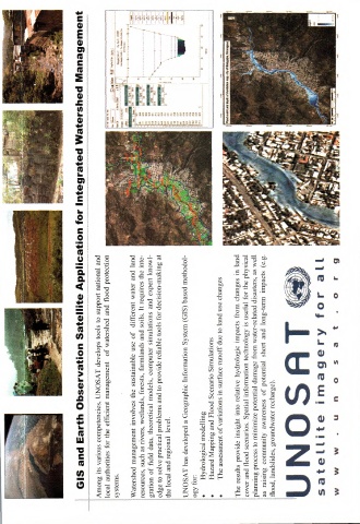
GIS and Earth Observation Satellite Application for Integrated Watershed Management

           Among its various competencies, UNOSAT develops tools to support national and
           local authorities for the efficient management of watershed and flood protection
           systems.

           Watershed management involves the sustainable use of different water and land
           resources, such as rivers, wetlands, forests, farmlands and soils. It requires the inte-
           gration of field data, theoretical models, computer simulations and expert knowl-
           edge to solve practical problems and to provide reliable tools for decision-making at
           the local and regional level.


           UNOSAT has developed a Geographic Information System (GIS) based methodol-
           ogy for:
          • Hydrological modelling
          • Hazard Mapping and Flood Scenario Simulations
          •  The assessment of variations in surface runoff due to land use changes


           The results provide insight into relative hydrologic impacts from changes in land
           cover and flood scenarios. Spatial information technology is useful for the physical
           planning process to minimize potential damage from water-related disasters, as well
           as raising community awareness of potential short and long-term impacts (e.g.
           flood, landslides, groundwater recharge).


           UNOSAT


           sateLLite imagery for aLL


           W  w w  • u n
                                            0 S  a  t • 0
                                                                                r 9