Page 201 - NUMINO TG_6A
P. 201
104_G6U13_TG 2014.4.17 6:55 PM ˘ ` 184
Activity 1 Scale Drawings
jOb ective Use scale to determine distances on a map.
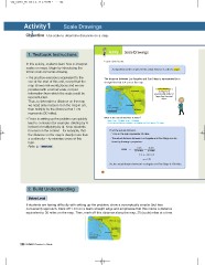
1. Textbook Instructions Activity 1 Scale Drawings
In this activity, students learn how to interpret Learn about scale.
scales on maps. Begin by introducing the
terms scale and scale drawing. A proportion used to represent the actual distance is called a scale.
The practice exercise is equivalent to the The distance between Los Angeles and San Diego is represented by a
one at the start of this unit, except that the straight line that is 4 cm on the map.
map shows real-world places and we are
provided with a formal scale, not just A scale drawing is a
information from which the scale could be drawing that is
reconstructed.
Thus, to determine a distance on the map proportionally smaller or
we need only measure it on the map in cm, larger than the actual
then multiply by the distance that 1 cm object.
represents (30 miles).
Errors in setting up the problem can quickly What is the actual distance in miles?
lead to confusion (for example, dividing by 4 Since 1 cm = 30 miles, 4 cm = 120 miles.
So, the actual distance between Los Angeles and San Diego is 120 miles.
instead of multiplying by 4). Keep students
focused on the context – for example, that Find the actual distance.
1 cm on the map represents 30 miles.
the distance on the map is clearly more than
The actual distance between Los Angeles and San Diego can be
a centimeter – to minimize errors of this found by forming a proportion.
type.
Refer to . 1 cm = 4 cm
30 miles a miles
scale
1 a = 30 4
a = 120
So, the actual distance between Los Angeles and San Diego is 120 miles.
110
2. Build Understanding
If students are having difficulty with setting up the problem, show a conceptually simpler (but less
convenient) approach. Mark off 1 cm on a blank straight edge and emphasize that this marks a distance
equivalent to 30 miles on the map. Then, mark off this distance along the map, 30 (scale) miles at a time.
184 NUMINO Teacher s Guide
Activity 1 Scale Drawings
jOb ective Use scale to determine distances on a map.
1. Textbook Instructions Activity 1 Scale Drawings
In this activity, students learn how to interpret Learn about scale.
scales on maps. Begin by introducing the
terms scale and scale drawing. A proportion used to represent the actual distance is called a scale.
The practice exercise is equivalent to the The distance between Los Angeles and San Diego is represented by a
one at the start of this unit, except that the straight line that is 4 cm on the map.
map shows real-world places and we are
provided with a formal scale, not just A scale drawing is a
information from which the scale could be drawing that is
reconstructed.
Thus, to determine a distance on the map proportionally smaller or
we need only measure it on the map in cm, larger than the actual
then multiply by the distance that 1 cm object.
represents (30 miles).
Errors in setting up the problem can quickly What is the actual distance in miles?
lead to confusion (for example, dividing by 4 Since 1 cm = 30 miles, 4 cm = 120 miles.
So, the actual distance between Los Angeles and San Diego is 120 miles.
instead of multiplying by 4). Keep students
focused on the context – for example, that Find the actual distance.
1 cm on the map represents 30 miles.
the distance on the map is clearly more than
The actual distance between Los Angeles and San Diego can be
a centimeter – to minimize errors of this found by forming a proportion.
type.
Refer to . 1 cm = 4 cm
30 miles a miles
scale
1 a = 30 4
a = 120
So, the actual distance between Los Angeles and San Diego is 120 miles.
110
2. Build Understanding
If students are having difficulty with setting up the problem, show a conceptually simpler (but less
convenient) approach. Mark off 1 cm on a blank straight edge and emphasize that this marks a distance
equivalent to 30 miles on the map. Then, mark off this distance along the map, 30 (scale) miles at a time.
184 NUMINO Teacher s Guide