
Page 189 - eProceeding - IRSTC & RESPEX 2017
P. 189
Dwikina Rosa Augusta / JOJAPS – JOURNAL ONLINE JARINGAN COT POLIPD
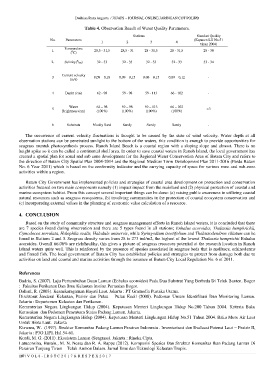
Table 4. Observation Result of Water Quality Parameters.
Stations Standart Quality
No. Parameters (Kepmen LH No.51
1 2 3 4
tahun 2004)
Temperature
1. 0 28,5 - 31,5 28,5 - 31 28 - 31,5 28 - 31,5 28 - 30
( C)
0
2. Salinity( / 00) 32 - 33 32 - 33 32 - 33 32 - 33 33 - 34
Current velocity
3 0,09 – 0,18 0,09 – 0,15 0.08 – 0.15 0,09 – 0,12 -
(m/s)
4 Depht (cm) 62 - 98 59 - 98 59 - 113 66 - 102 -
Water 62 – 98 59 – 98 59 – 113 66 – 102
5 >3
Brightness (cm) (100%) (100%) (100%) (100%)
6 Substrats Muddy Sand Sandy Sandy Sandy -
The occurrence of current velocity fluctuations is thought to be caused by the state of wind velocity. Water depth at all
observation stations can be penetrated sunlight to the bottom of the waters, this condition is enough to provide opportunities for
seagrass muntuk photosynthesis process. Ranoh Island Beach is a coastal region with a sloping slope and almost. There is no
height spike so it can be called a continental shelf area. In order to save coastal waters in Ranoh Island, the local government has
created a spatial plan for zonal and sub zone development for the Regional Water Conservation Area of Batam City and refers to
the direction of Batam City Spatial Plan 2004-2014 and the Regional Medium Term Development Plan 2011-2016 (Perda Batam
No. 6 Year 2011) which is based on the conformity indicator and the carrying capacity of space for various zone and sub-zone
activities within a region.
Batam City Government has implemented policies and strategies of coastal area development on protection and conservation
activities focused on two main components namely (1) impact impact from the mainland and (2) physical protection of coastal and
marine ecosystem habitat. From this concept several important things can be done: (a) raising public awareness in utilizing coastal
natural resources such as seagrass ecosystems, (b) involving communities in the protection of coastal ecosystem conservation and
(c) incorporating external values in the planning of economic value calculation of a resource.
4. CONCLUSION
Based on the study of community structure and seagrass management efforts in Ranoh Island waters, it is concluded that there
are 7 species found during observation and there are 5 types found in all stations; Enhalus acoroides, Thalassia hemphrichii,
Cymodocea serrulata, Halophila ovalis, Halodule uninervis, while Syringodium isoetifolium and Thalassodendron ciliatum can be
found in Stations 2 and 3. Seagrass density varies from 28 to 273 ind/m2, the highest of the lowest Thalassia hemprichii Enhalus
acoroides. Overall 66.06% are rich/healthy, this gives a picture of seagrass resources potential at the research location in Ranoh
Island waters quite well. This is reinforced by the presence of spesies associated in seagrass beds that is molluscs, echinoderms
and finned fish. The local government of Batam City has established policies and strategies to protect from damage both due to
activities on land and coastal and marine activities through the issuance of Batam City Local Regulation No. 6 of 2011.
References
Badria, S. (2007). Laju Pertumbuhan Daun Lamun (Enhalus acoroides) Pada Dua Substrat Yang Berbeda Di Teluk Banten. Bogor
: Fakultas Perikanan Dan Ilmu Kelautan Institut Pertanian Bogor.
Dahuri, R. (2003). Keanekaragaman Hayati Laut. Jakarta : PT Gramedia Pustaka Utama.
Direktorat Jenderal Kelautan, Pesisir dan Pulau – Pulau Kecil (2008). Pedoman Umum Identifikasi Dan Monitoring Lamun.
Jakarta : Departemen Kelautan dan Perikanan.
Kementerian Negara Lingkungan Hidup (2004). Keputusan Menteri Lingkungan Hidup No.200 Tahun 2004. Kriteria Baku
Kerusakan dan Pedoman Penentuan Status Padang Lamun. Jakarta.
Kementerian Negara Lingkungan Hidup (2004). Keputusan Menteri Lingkungan Hidup No.51 Tahun 2004. Baku Mutu Air Laut
Untuk Biota Laut. Jakarta
Kiswara, W. (1997). Struktur Komunitas Padang Lamun Perairan Indonesia . Inventarisasi dan Evaluasi Potensi Laut – Pesisir II,
Jakarta : P3O LIPI. Hal 54-61.
Kordi, M. G. (2011). Ekosistem Lamun (Seagrass). Jakarta : Rineka Cipta.
Latuconsina, Husain., M. N. Nessa dan R. A. Rappe (2012). Komposisi Spesies Dan Struktur Komunitas Ikan Padang Lamun Di
Perairan Tanjung Tiram – Teluk Ambon Dalam. Jurnal Ilmu dan Teknologi Kelautan Tropis.
187 | V O L 8 - I R S T C 2 0 1 7 & R E S P E X 2 0 1 7